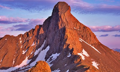
Wetterhorn and Uncompahgre Peak
Wetterhorn and Uncompahgre Peak from the Matterhorn Creek Trailhead. Note, a high-clear 4WD vehicle is required to reach the trailhead.
This route begins at the Matterhorn Creek Trailhead. From there, follow the standard 14ers.com routes to Wetterhorn and Uncompahgre Peaks.
Wetterhorn Peak SE Ridge:
https://www.14ers.com/route.php?route=wett1
Uncompahgre Peak South Ridge:
https://www.14ers.com/route.php?route=unco1
Location of TH - Matterhorn Creek Trailhead - Google Maps
- Suitable Activities: Backpacking, Scrambling
- Seasons: July, August, September
- Weather: View weather forecast
- Difficulty: Difficult D
- Length: 17.0 mi
- Elevation Gain: 6,400 ft
- 14,318 ft
-
Land Manager:
U.S. Forest Service
Uncompahgre Field Office, Gunnison Ranger District (GMUG)
- Parking Permit Required: USFS Permits & Passes
- Recommended Party Size: 8
- Maximum Party Size: 12
- Maximum Route/Place Capacity: 12
There are no resources for this route/place. Log in and send us updates, images, or resources.
