The West End
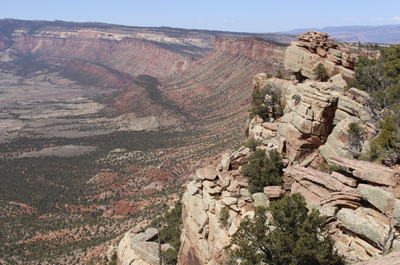
The West End is a historic and rugged mining region in western Montrose and San Miguel Counties, Colorado. The area contains part of the Uncompahgre Plateau and is home to multiple native petroglyph sites.
The West End includes the towns of Nucla, Naturita, Bedrock, Redvale, Paradox, and Norwood. Because it has never been ranched or developed, it is recognized for its pristine native characteristics. The Sewemup Mesa Wilderness Study Area (WSA), is managed by BLM but not yet designated as an official wilderness by Congress. The area is protected by the Colorado Wilderness Act which provides a description and map.
Alternate Titles Include:
Shaman Panel - 0.25 miles RT. Shaman Panel is located in Long Park, about 11 miles northwest of Naturita. Petroglyph panels are situated a short distance up a rugged canyon that requires scrambling around two easy spillovers.
Roc Creek Petroglyphs - 2 miles RT. Roc Creek is located north of Naturita along Highway 141. The property owner has generously granted us permission to visit this site.
Sewemup Mesa - 2 miles RT. Sewemup Mesa WSA is located farther north along Highway 141 towards Gateway. We will gain access to the mesa by hiking and scrambling up a use trail into the WSA.
- Suitable Activities: Climbing, Conservation, Family, Hiking, Mountaineering
- Seasons: Year-round
- Weather: View weather forecast
- 10,300 ft
- Land Manager: Bureau of Land Management
- Parking Permit Required: BLM Permits & Passes
- Recommended Party Size: 12
- Maximum Party Size: 12
- Maximum Route/Place Capacity: 12
- AllTrails
- PeakBagger
- Lists of John,
- Summit Post
- USGS
This is a list of titles that represent the variations of trips you can take at this route/place. This includes side trips, extensions and peak combinations. Not seeing a title that fits your trip? Log in and send us updates, images, or resources.
- The West End - Shaman Panel
- The West End - Roc Creek Petroglyphs
- The West End - Sewemup Mesa
There are no resources for this route/place. Log in and send us updates, images, or resources.
