Waterton Canyon
This route is along a maintained road closed to public vehicle access, an occasional Denver Water vehicle may be encountered. Gentle grade and water features along the South Platte River lead you through an area known for frequent wildlife sightings.
Waterton Canyon to Strontia Springs Dam: 13 miles, 380 feet of elevation gain
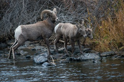
Travel through the Waterton Canyon following the South Platte River up to Strontia Springs Dam with a chance to see wildlife such as big horn sheep.
For further information and any restrictions see: Waterton Canyon/Strontia Springs Reservoir | Denver Water
Directions to parking lot: Waterton Canyon Trailhead - Google Maps
- Suitable Activities: Biking, Hiking, Photography
- Seasons: Year-round
- Weather: View weather forecast
- Land Manager: Denver
- Parking Permit Required: Other
- Recommended Party Size: 12
- Maximum Party Size: 25
- Maximum Route/Place Capacity: 25
This is a list of titles that represent the variations of trips you can take at this route/place. This includes side trips, extensions and peak combinations. Not seeing a title that fits your trip? Log in and send us updates, images, or resources.
- Waterton Canyon to Strontia Springs Dam
- Goat Mountain
- Waterton Canyon and Chatfield SP Perimeter Trail
There are no resources for this route/place. Log in and send us updates, images, or resources.
