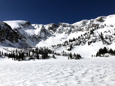
Upper Forest Lakes Trail
This trail starts at the East Portal of the Moffat Tunnel outside of Rollinsville. It starts out following South Boulder Creek then turns north appx. 1.2 miles onto Forest Lakes Trail (FS 809). The upper lake below the Continental Divide is reached in 2.6 miles from the junction.
The trail starts out at the East Portal at 9,237 feet elevation. It climbs steadily through heavy forest until reaching Lower Forest lake. It then breaks out to views of the Continental Divide and stays above tree line until reaching the Upper Lake in 1/2 mile. The high point is 10,878 just before the lake and total elevation gain is 1,778 feet and 7.6 miles. This trail is excellent for hiking and snowshoeing. Arapaho Lakes can also be accessed from this trail.
- Suitable Activities: Backcountry Skiing/Splitboarding, Hiking, Snowshoeing
- Snowshoeing Category: Intermediate
- Seasons: Year-round
- Weather: View weather forecast
- Avalanche Terrain Rating Simple View avalanche forecast.
- Difficulty: Mod B
- Length: 7.6 mi
- Elevation Gain: 1,778 ft
- 10,878 ft
-
Land Manager:
U.S. Forest Service
James Peak Wilderness Area, Boulder Ranger District (ARNF)
- Parking Permit Required: USFS Permits & Passes
- Recommended Party Size: 12
- Maximum Party Size: 24
- Maximum Route/Place Capacity: 12
- AllTrails
- COTREX
- caltopo
This is a list of titles that represent the variations of trips you can take at this route/place. This includes side trips, extensions and peak combinations. Not seeing a title that fits your trip? Log in and send us updates, images, or resources.
- Upper Forest Lake
- Forest Lakes
There are no resources for this route/place. Log in and send us updates, images, or resources.
