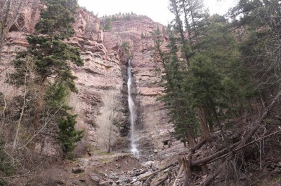
Upper Cascade Falls and Chief Ouray Mine
A steep trail with some exposure but the rewards are great vistas and beautiful a waterfall. Some relic mine structures at the top.
From the TH follow the Cascade Amphitheater Trail about 1,000' to a Y intersection. Bear left onto Trail #213, the Upper Cascade Falls Trail. Right past the falls there are old structures related to the Chief Ouray Mine. Scree in places, slippery gravel slopes, and a water crossing. Hiking poles recommended.
Alternate titles -
Upper Cascade Falls
Chief Ouray Mine
- Suitable Activities: Hiking
- Seasons: March, April, May, June, July, August, September, October, November
- Weather: View weather forecast
- Avalanche Terrain Rating Simple View avalanche forecast.
- Difficulty: Moderate
- Length: 5.0 mi
- Elevation Gain: 2,200 ft
- 10,140 ft
-
Land Manager:
U.S. Forest Service
Ouray Ranger District (GMUG)
- Parking Permit Required: USFS Permits & Passes
- Recommended Party Size: 12
- Maximum Party Size: 12
- Maximum Route/Place Capacity: 12
This is a list of titles that represent the variations of trips you can take at this route/place. This includes side trips, extensions and peak combinations. Not seeing a title that fits your trip? Log in and send us updates, images, or resources.
- Upper Cascade Falls and Chief Ouray Mine - Upper Cascade Falls
- Upper Cascade Falls and Chief Ouray Mine - Chief Ouray Mine
There are no resources for this route/place. Log in and send us updates, images, or resources.
