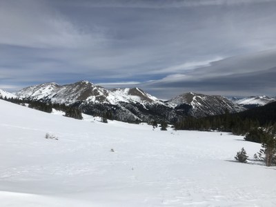
Vasquez Peak
Vasquez Peak stands at 12,947 ft. This mountain range extends through the Vasquez Peak Wilderness in the south and the Byers Peak Wilderness in the north.
Unnamed Saddle On West Side of Vasquez Peak:
Unnamed saddle on the west side of Vasquez Peak on the Clear Creek-Grand County line is a moderate hike or snowshoe northeast on Jones Pass and northwest of the Henderson mine. The trailhead is at 10,440 feet along the Jones Pass Road; timberline is about 11,600 feet. The saddle is in the alpine tundra and has outstanding vistas of high peaks and deep glacially scoured valleys on both sides of the saddle. The saddle is accessed via the Stanley CDT Spur and the Berthoud Pass West Trail (Mount Nystrom Trail).
- Suitable Activities: Hiking, Snowshoeing
- Snowshoeing Category: Intermediate
- Seasons: Year-round
- Weather: View weather forecast
- View avalanche forecast.
- Difficulty: Easy B
- Elevation Gain: 1,500 ft
- 11,980 ft
- Land Manager: U.S. Forest Service
- Parking Permit Required: USFS Permits & Passes
- Recommended Party Size: 12
- Maximum Party Size: 12
- Maximum Route/Place Capacity: 12
- caltopo
- caltopo
This is a list of titles that represent the variations of trips you can take at this route/place. This includes side trips, extensions and peak combinations. Not seeing a title that fits your trip? Log in and send us updates, images, or resources.
- Unnamed Saddle on West Side of Vasquez Peak
- Vasquez Peak via Southeast Basin
There are no resources for this route/place. Log in and send us updates, images, or resources.
