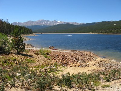
Turquoise Lake
Sitting deep in the forest west of Leadville, Turquoise Lake takes its name from the Turquoise mines that produced the semiprecious stone in Leadville's not too distant past. Turquoise Lake provides some of the most beautiful views on the Leadville Ranger District.
A spot prized for its fishing, camping, and hiking, Turquoise Lake provides some of the most beautiful views on the Leadville Ranger District
Starting from the winter trailhead at the Sugarloaf Dam, follow the popular route along the south shore of the lake that is open to motorized and non-motorized use. This is a technically easy trip. It's the length that makes it difficult. Go as far as the group feels like going and then re-trace your steps back to the starting point.
Directions - Turquoise Lake - Google Maps
Alternate title - Turquoise Lake - RMOTHG camping
Additional information:
- Suitable Activities: Backcountry Nordic Skiing, Hiking, Nordic Skiing, Snowshoeing
- Snowshoeing Category: Intermediate
- Seasons: Year-round
- Weather: View weather forecast
- Avalanche Terrain Rating Simple
- Difficulty: intermediate
- Length: 15.0 mi
- Elevation Gain: 1,550 ft
- 10,710 ft
-
Land Manager:
U.S. Forest Service
Leadville Ranger District (PSINF)
- Parking Permit Required: USFS Permits & Passes
- Recommended Party Size: 30
- Maximum Party Size: 30
- Maximum Route/Place Capacity: 30
- AllTrails
- caltopo
- COTREX
- USGS 7.5 Leadville North
- USGS 7.5 Homestake Reservoir
This is a list of titles that represent the variations of trips you can take at this route/place. This includes side trips, extensions and peak combinations. Not seeing a title that fits your trip? Log in and send us updates, images, or resources.
- Turquoise Lake - RMOTHG camping
There are no resources for this route/place. Log in and send us updates, images, or resources.
