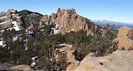
The Crags Trail
The Crags Trail - Forest Service Trail #664. This trail is 4.54 miles round trip with an elevation gain of 818 feet and an elevation loss of 38 feet.
Starting at the Crags parking lot on Forest Service Road 383, cross the road and the creek near the restrooms. The trail switchbacks steeply up a hillside for approximately 1/2 mile. The trail levels out as it approaches an intersection. Take the trail to the left to the Crags. Do not go right on the Devil's Playground Trail. Walk through forested and grassy areas in a valley to the north of Fourmile Creek. At approximately 2.14 miles the trail goes through a shady ravine and then heads steeply to the north up to the Crags rocks. The trail will disappear along the sloping rock face at approximately 2.32 miles. Walk up the sloping rock face to the top of the Crags. Return via the same route to the trailhead. It is a Moderate A trail.
Location of TH - Crags Trail Head - Google Maps
- Suitable Activities: Hiking, Snowshoeing
- Snowshoeing Category: Beginner
- Seasons: Year-round
- Weather: View weather forecast
- Difficulty: Mod A
- Length: 4.54 mi
- Elevation Gain: 818 ft
- 10,773 ft
-
Land Manager:
U.S. Forest Service
Pikes Peak Ranger District (PSINF)
- Parking Permit Required: USFS Permits & Passes
- Recommended Party Size: 12
- Maximum Party Size: 12
- Maximum Route/Place Capacity: 12
- Trails Ilustrated of the Pikes Peak Region
- Ormes Pikes Peak Atlas
- Pikes Peak Area #7
There are no resources for this route/place. Log in and send us updates, images, or resources.
