St. Vrain Mountain
The St. Vrain Mountain trailhead crosses Indian Peak Wilderness and Rocky Mountain National Park. The summit is at 12,162', 9 miles roundtrip, and over 3,000' elevation gain.
Please view this document with everything you need to know about Rocky Mountain National Park
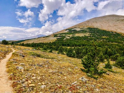
The trail scales a steep gulch to tree line, then moderates across broad tundra saddles and ridges to the base of the summit, where an access route splits off and climbs 800' in just .8 miles to the top:
The trail climbs steadily up the valley's north side through lodgepole and aspen to the Indian Peaks Wilderness Boundary (.7 miles : 9,332'), and a swath of diminutive, sparsely plotted limber pine (1.0 miles : 9,650').
The trail switchbacks hard left (west) one final time (1.5 miles : 10,008') before turning sharply south across the valley with perspective on the route you've taken to this point (1.75 miles : 10,215').
Grades briefly moderate at 2.1 miles (10,405'), then steepen back up the south valley wall. The trail twists steeply through uniformly tall spruce (a counter-intuitive contrast to the forest below), turning sharply south one last time before clearing tree line (2.65 miles : 10,765').
Travel eases along a broad tundra saddle between the triangulated shoulders of Meadow Mountain (11,632'), an unnamed peak, and St. Vrain Mountain. It reaches the Rocky Mountain National Park Boundary (3.15 miles : 11,180') and levels for nearly half a mile on a south heading with some of the route's best views.
This airy section overlooks Rocky Mountain's Wild Basin Area, Mount Copeland (13,176'), Ouzel Peak (12, 12,716'), Mahana Peak (12,632'), Longs Peak (14,259') and Mt Meeker (13,911').
Those not aiming for the summit will be content with views along this stretch. The trail exits Rocky Mountain National Park (3.6 miles : 11,335') and threads a few pockets of krummholz to an unmarked turnoff for St Vrain Mountain.
A trio of unassuming cairns are all that initially guide you off the main trail toward the summit; remain vigilant and anticipate this point - more navigational help awaits up-slope.
Leave the main trail (3.65 miles : 11,360') and aim for a band of krummholz approximately 200 yards away. Once through look for cairns and, most importantly, Indian Peaks - Rocky Mountain National Park Boundary posts to your right (north).
St. Vrain Mountain's unmaintained summit route hugs the IPW side of the boundary posts, and generally favors the most accommodating terrain. Still, anticipate rugged talus, steep grades, and snowfields year-round on the strenuous .75 mile summit push.
St. Vrain Mountain (4.45 miles : 12,162') is rounded with 2 wind shelters and unabated views. Continue along its west ridge to the Elk Tooth formation and base of Ogallala Peak (13,138') on the Divide.
Source: ProTrails - St. Vrain Mountain
- Suitable Activities: Backpacking, Hiking, Snowshoeing
- Seasons: Year-round
- Weather: View weather forecast
- Difficulty: Mod C
- Length: 8.9 mi
- Elevation Gain: 3,222 ft
- 12,162 ft
-
Land Manager:
Land Manager Varies
Rocky Mountain National Park, Boulder Ranger District (ARNF)
- Parking Permit Required: Other
- Recommended Party Size: 12
- Maximum Party Size: 12
- Maximum Route/Place Capacity: 12
- National Geographic from REI
There are no resources for this route/place. Log in and send us updates, images, or resources.
