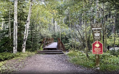
Silverdale Historic Area Trails
Hike, snowshoe, or bike on old mining trails, now upgraded for visiting the historic Silverdale and Argentine mining districts, and the remains of the town of Silverdale.
This trail complex is easy to reach and provides a variety of lengths and elevation gains in combination. Clear Creek winds through the area. Georgetown provides detailed info about the district and its trails. Clear Creek County manages the trails and provides trail info and updates.
The northernmost TH, for the Rutherford Trail, starts in Georgetown. The southern end of the trail complex is available at the Silverdale Interpretive Site parking lot. A large concrete structure is all that remains of Colorado Central Mill. See the alternate titles for a list of the interconnected trails.
- Suitable Activities: Biking, Hiking, Snowshoeing
- Seasons: Year-round
- Weather: View weather forecast
- Avalanche Terrain Rating Simple View avalanche forecast.
- 10,129 ft
- Land Manager: Clear Creek County
- Parking Permit Required: Other
- Recommended Party Size: 12
- Maximum Party Size: 12
- Maximum Route/Place Capacity: 12
- AllTrails
- CoTrex
- Clear Creek County
This is a list of titles that represent the variations of trips you can take at this route/place. This includes side trips, extensions and peak combinations. Not seeing a title that fits your trip? Log in and send us updates, images, or resources.
- Rutherford Trail 2.1 miles, 734' gain
- Sporting Times Trail .9 miles, 283' gain
- Chicago Road .4 miles, 583' gain
- Anna Trail .8 miles, 123' gain
- Railbed Trail .75 miles, 113' gain
- Highline Trail .8 miles, 79' gain
- Powerline Trail 1.5 miles, 1558' gain
There are no resources for this route/place. Log in and send us updates, images, or resources.
