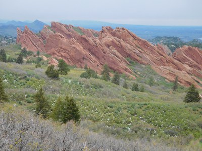
Roxborough State Park
Roxborough State Park is located southwest of Denver and connects to Douglas County Open Space Trails, Pike National Forest Trails, Waterton Canyon, and the Colorado Trail.
Due to popularity & limited parking all groups must contact the park prior to their visit.
Details as follows:
- At any time of the year:
- Groups of 10 or more need a permit (even if just hiking)
- Groups of 9 or less don’t need a permit but must notify the park via email stating the date and time of visit, the number in the party, and intended trails
- No Groups of any size are permitted on weekends, May 1 through October 31 without prior approval from the Park Manager
- Please fill out the permit linked here.
- Email address to send the completed permit for notification is roxborough.park@state.gov.us. You can also call 303-973-3959. Notice is requested 90 days in advance but may be given with shorter notice depending upon the situation.
Carpenter Peak: 6.3 miles, 1,059 feet of elevation gain
This trail is popular and is open year around. The trail is out and back. This trail is a high use trail during the spring to fall seasons. The trail is scenic for the entire trip and is noted for its sandstone red fins and the commanding panoramic views.
Carpenter Peak to Powerline Trail: 7.9 miles, 1,407 feet of elevation gain
Waterton Canyon to Roxborough State Park: 13 miles, 2,100 feet of elevation gain
This route starts at the Waterton Canyon trailhead to hike up the canyon, then uses the Roxborough connector trail at Stevens Gulch just past the Strontia Springs Dam to get to the Powerline trail in the park. From the Powerline trail there is access to Carpenter Peak or the Elk Valley trail.
South Rim & Willow Creek Loop: 3 miles, 465 feet of elevation gain
The South Rim Trail begins approximately 0.5 miles from the Visitor Center starting on the Carpenter Peak Trail. The South Rim Trail is a single track trail that is considered moderate for hiking difficulty. It is approximately 1.8 miles long with approximately a 500 foot elevation gain. The trail connects to the Carpenter Peak and Willow Creek Trails. The Willow Creek Trail winds through scrub oak and the Willow Creek riparian area. The Willow Creek Trail is known for its abundance of wildflowers and variety of birds.
Indian Creek to Roxborough Park - 4 miles - elevation gain - 2288 ft
- Suitable Activities: Hiking, Nordic Skiing, Snowshoeing
- Seasons: Year-round
- Weather: View weather forecast
-
Land Manager:
Colorado Parks & Wildlife
Roxborough State Park
- Parking Permit Required: State Parks Entrance Fee / Pass
- Recommended Party Size: 12
- Maximum Party Size: 30
- Maximum Route/Place Capacity: 15
- Waterton Canyon Recreation map
- Roxborough State Park
This is a list of titles that represent the variations of trips you can take at this route/place. This includes side trips, extensions and peak combinations. Not seeing a title that fits your trip? Log in and send us updates, images, or resources.
- Roxborough State Park - Carpenter Peak
- Roxborough State Park - Carpenter Peak to Powerline Trail
- Roxborough State Park - Powerline Trail
- Waterton Canyon to Roxborough State Park
- Roxborough State Park - South Rim & Willow Creek Trails
- Roxborough State Park - Indian Creek to Roxborough Park
There are no resources for this route/place. Log in and send us updates, images, or resources.
