RMNP - Wild Basin TH
Restrooms available at the Visitor's Center.
Please view this document with everything you need to know about Rocky Mountain National Park
See a Wild Basin Trail Orientation Map here.
Alternate titles:
Hidden Falls: 4.4 mi, 500 ft gain
Follows the North St. Vrain Creek Trail past Copeland Falls, then on to Hidden Falls where, in winter, you may see ice climbers testing their skills on the frozen waterfall.
Lion Lakes and Snowbank: 14 mi, 3,021 ft gain
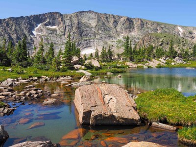
The lakes are beautiful as well as Trio Falls with Chiefs Head Peak in the background as you pass Lion Lakes 1.
Blue Bird Lake: 12.6 miles, 2,478 ft gain
On the way, pass Copeland Falls, Calypso Cascades, and Ouzel Falls. On the Blue Bird Trail you will see high peaks Copeland, Alice, Ouzel, Mahana, and Tanima. Longs Peak and Mount Meeker rise to the north.
Thunder Lake and Pine Ridge: 10.6 mi, 2,234 ft gain
A summer classic appropriate for folks who can carry a full pack. The Wild Basin trail to Thunder Lake follows a creek through forest with stops at Copeland Falls, Calypso Cascades, and Ouzel Falls along the way.
Thunder & Fan Falls Bushwhack: 15 mi, 3,000 ft gain
There are 28 named waterfalls in Rocky Mountain National Park. This hike visits two of the more obscure, distant ones. Thunder Falls is heard but cannot be seen from any trail. Fan Falls can only be seen from the Boulder-Grand Pass Trail beyond Thunder Lake. It is rarely visited because there is no trail within a mile of it. It is, however, one of the longest cascading waterfalls in RMNP.
Take the Wild Basin Trail to the backcountry campsite "shortcut" which connects to the Thunder Lake Trail. From there, branch off on the Lion Lakes Trail. Just short of Lion Lake #1, leave the trail to bushwhack and follow your ears to Thunder Falls. From there, bushwhack steeply up from the falls to Lion Lake #1. Then head cross-country through wildflower meadows, over creeks, and discovering unnamed ponds in some of the most beautiful terrain in all RMNP. From the top of Fan Falls, descend 800' of very steep terrain and bushwhack your way toward Thunder Lake where you will pick up the Boulder-Grand Pass trail taking it to the ranger cabin at Thunder Lake. Return to the trailhead using the trail system.
Ouzel Lake: 10 miles - 1711 ft elevation gain
From the Wild Basin TH on the Wild Basin, Bluebird Lake, and Ouzel Lake Trails, 10 mi OB, 1711.’ You pass 3 waterfalls on the trail to the lake - Copeland Falls, Calypso Cascades, and Ouzel Falls. At Ouzel Lake you have a great view of Mount Copeland. Along the way, view the remains of the 1978 Ouzel Fire.
Suggested Backpacking Itinerary:
Day 1 (6 miles, 2,234 ft elevation gain): Meet at RMNP Wild Basin entrance. Hike along Wild Basin Trail, following signs for Thunder Lake. The sites are just above/past the lake (not the group site). Make camp and spend the afternoon exploring and relaxing.
Day 2 (4.2 miles without side trips): Break camp and head back down the trail to Pine Ridge campsite. Make camp at Pine Ridge for the night. Then 1.4 miles back to the car.
- Suitable Activities: Backpacking, Hiking, Snowshoeing
- Seasons: Year-round
- Weather: View weather forecast
- Avalanche Terrain Rating Simple
-
Land Manager:
National Park Service
Rocky Mountain National Park
- Parking Permit Required: National Park Entrance Fees
- Recommended Party Size: 12
- Maximum Party Size: 25
- Maximum Route/Place Capacity: 25
This is a list of titles that represent the variations of trips you can take at this route/place. This includes side trips, extensions and peak combinations. Not seeing a title that fits your trip? Log in and send us updates, images, or resources.
- RMNP - Wild Basin TH - Hidden Falls
- RMNP - Wild Basin TH - Lion Lakes and Snowbank
- RMNP - Wild Basin TH - Blue Bird Lake
- RMNP - Sandbeach Lake
- RMNP - Ouzel Lake
There are no resources for this route/place. Log in and send us updates, images, or resources.
