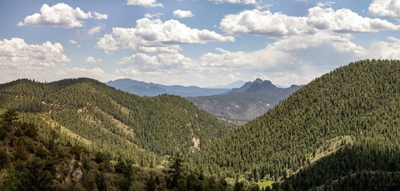
Reynolds Park
A beautiful Jefferson County OS with 17 miles of multiple linking trails, and running streams. At the crest of the Eagle's View Trail, enjoy views all the way to Pikes Peak.
The park has restrooms at the parking lot/trailhead, on the west side of Foxton Rd.
The North Fork Trail starts on the east side of Foxton Rd. and leads all the way to the South Platte River, tying into the regional trail system.
The Idylease Campground, on the east side of Foxton Rd., offers semi-primitive, tent-only, walk-in camping in designated sites. Camping permits must be obtained online at least 24 hours in advance. Reserve a Campsite.
Alternate titles -
North Fork Trail -- 10 miles, 1,000' elevation gain
Songbird and Eagle's View Trails -- 6 miles, 1320' elevation gain
- Suitable Activities: Camping, Hiking, Snowshoeing
- Seasons: Year-round
- Weather: View weather forecast
- 8,100 ft
- Land Manager: Jefferson County Open Space
- Parking Permit Required: Other
- Recommended Party Size: 12
- Maximum Party Size: 14
- Maximum Route/Place Capacity: 12
- AllTrails
- COTREX
This is a list of titles that represent the variations of trips you can take at this route/place. This includes side trips, extensions and peak combinations. Not seeing a title that fits your trip? Log in and send us updates, images, or resources.
- Reynolds Park - North Fork Trail
- Reynolds Park - Songbird and Eagle's View Trails
There are no resources for this route/place. Log in and send us updates, images, or resources.
