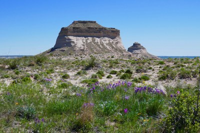
Pawnee Buttes
Hike through Pawnee National Grassland to prominent sandstone Pawnee Buttes. Located in northeastern Colorado not far from the Nebraska border. Popular for photography and birding year round.
The TH is Pawnee Buttes TH Pawnee Buttes Trailhead - Google Maps
While the main trail is open year-round, there are rapture closures March 1 through June 30, which includes the buttes themselves as well as a side trail. At those times you may view golden eagles and prairie falcons. Signs clearly mark what areas are closed, including the overlook area behind the wooden fencing. For more information, please see https://www.fs.usda.gov/detail/arp/news-events/?cid=FSEPRD541787
- Suitable Activities: Exploring Nature, Hiking, Photography
- Seasons: Year-round
- Weather: View weather forecast
- Difficulty: Easy
- Length: 5.0 mi
- Elevation Gain: 325 ft
- 5,305 ft
-
Land Manager:
U.S. Forest Service
Pawnee National Grassland (ARNF)
- Parking Permit Required: USFS Permits & Passes
- Recommended Party Size: 12
- Maximum Party Size: 12
- Maximum Route/Place Capacity: 12
- AllTrails
- CoTrex
There are no resources for this route/place. Log in and send us updates, images, or resources.
