Northridge, Squirrel Creek, Carhart Trail Loop
Loop hike: 7.8 miles, 1300' gain, easy B hike. Out & Back hike: 8-9 miles, 1,600-1,800' gain, easy B.
Alternate Titles:
- Carhart trail to Squirrel Creek Historic Pavilion
- Carhart, Squirrel Creek, Cascade Trail Out & Back
- Coupler Trail via Squirrel Creek Trail
- Northridge, Squirrel Creek, Carhartt Trail Loop
Northridge, Squirrel Creek, Carhart Trail Loop:
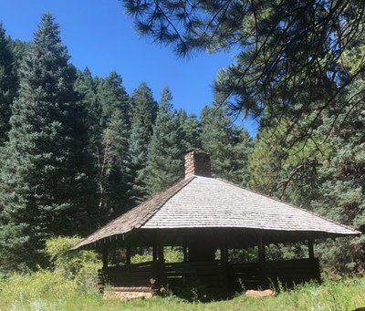
The hike starts at the Archery Range Road Trailhead in Beulah. From the trailhead we will enter the Pueblo Mountain Park via the Archery Range Trail to the Northridge Trail until it meets Squirrel Creek. We will then cross Squirrel Creek into the San Isabel National Forrest following the Squirrel Creek Trail #1384 to the historic Pavilion where we will eat lunch. We will then return via the Squirrel Creek Trail, cross the creek and take Carhart Trail in the Pueblo Mountain Park back to the trailhead.
Carhart, Squirrel Creek, Cascade Trail Out & Back:
The out and back hike starts outside the Pueblo Mountain Park at the Archery Range Trailhead parking lot and then enters Pueblo Mountain Park in Beulah following Carhart Trail to Squirrel Creek. The hike then goes into Squirrel Creek Canyon crossing Squirrel Creek into San Isabel National Forest following the Squirrel Creek Trail with multiple easy-to-navigate water crossings. The remnants of the Arthur Carhart’s final stages of development of a recreation area that became an inspiration for Forest Service campgrounds in the future can be seen as Squirrel Creek Trail is followed. At a right-hand turn of Squirrel Creek Trail, the hike then goes off trail to follow the remnants of the lower portion of Cascade Trail that parallels cascading water falls when Squirrel Creek is running full. Depending on the condition of the foot bridges along what is left of the lower Cascade Trail, the trail may be followed up to where it was washed out by a flood in 1947. The hike is 8-9 miles with 1600-1800’ gain and is classified as Easy Class B with some steeper areas of moderate gain especially when returning back up Carhart Trail.
- Suitable Activities: Hiking, Snowshoeing
- Snowshoeing Category: Basic
- Seasons: Year-round
- Weather: View weather forecast
- Difficulty: Easy B
- Length: 8.0 mi
- Elevation Gain: 1,300 ft
- 7,374 ft
-
Land Manager:
U.S. Forest Service
San Carlos Ranger District (PSINF)
- Parking Permit Required: USFS Permits & Passes
- Recommended Party Size: 10
- Maximum Party Size: 10
- Maximum Route/Place Capacity: 12
This is a list of titles that represent the variations of trips you can take at this route/place. This includes side trips, extensions and peak combinations. Not seeing a title that fits your trip? Log in and send us updates, images, or resources.
- Carhart trail to Squirrel Creek Historic Pavilion
- Carhart, Squirrel Creek, Cascade Trail Out & Back
- Coupler Trail via Squirrel Creek Trail
- Northridge, Squirrel Creek, Carhartt Trail Loop
There are no resources for this route/place. Log in and send us updates, images, or resources.
