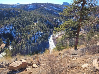
North Fork Trail
Easy hike with many stops for learning and viewing the scenery. North Fork of South Platte River, in a remote river canyon near Denver. trail.
Before creating a trip, click “Activities” below to make sure there isn’t already a trip booked to the same place on the same date.
For further information and any restrictions see: Reynolds Park | Jefferson County, CO (jeffco.us)
Directions to parking lot: Idylease Campground - Google Maps
Reynolds Park Trailhead - Google Maps
If this trail is done as a through hike it can be done as a key exchange, or a car shuttle. As a key exchange parking at both the Idylease Campground and take another car to the other end of the trail (about 20 minutes away heading southeast) and following the North Fork of the South Platte river and park at the trail head.
Alternate title data:
North Fork Trail from Idylease Campground - 9.9 miles - 1003 ft elevation gain
North fork Trail for Reynolds Park TH - 9.9 miles - 1600 ft elevation gain
Thru-Hike North Fork Trail
To review the Trip Leader Checklist see: Shared R:P+Trip Leader Activity Checklists - Google Docs
- Suitable Activities: Biking, Environmental Awareness, Hiking
- Seasons: Year-round
- Weather: View weather forecast
- Difficulty: Moderate
- Length: 9.9 mi
- 7,684 ft
- Land Manager: Jefferson County Open Space
- Parking Permit Required: Other
- Recommended Party Size: 18
- Maximum Party Size: 14
- Maximum Route/Place Capacity: 14
This is a list of titles that represent the variations of trips you can take at this route/place. This includes side trips, extensions and peak combinations. Not seeing a title that fits your trip? Log in and send us updates, images, or resources.
- North Fork Trail from Idylease Campground
- North fork Trail for Reynolds Park TH
- Thru-Hike North Fork Trail
There are no resources for this route/place. Log in and send us updates, images, or resources.
