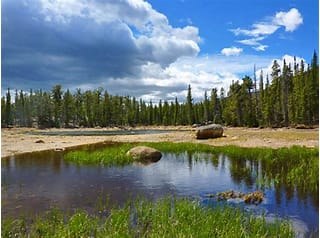
North Fork of the Big Thompson River Trail
The Dunraven Trailhead in RMNP leads to the North Fork of the Big Thompson River Trail (#929) and eventually into the Comanche Peak Wilderness Area.
Trailhead coordinates are : 40.48454843948257, -105.48446117791173
Out-and-back-along this pretty wooded trail passes a meadow at the 3-mile mark, site of an 1890 resort.Although the 2013 flood washed away the remainder of the buildings, this is where Fred Sprague built a resort camp in the 1890s called "Deserted Village."
The trail continues on out of the Park to connect with the North Boundary Trail #958 and eventually merges into the Lower Lost Lake Trail, the southern end of the Stormy Peaks Trail, and the South Signal Mountain Trail # 928.2.
- Suitable Activities: Backpacking, Camping, Hiking
- Snowshoeing Category: Intermediate
- Seasons: February, March, April, May, June, July, August, September, October, November
- Weather: View weather forecast
- Avalanche Terrain Rating Complex View avalanche forecast.
- Difficulty: moderate
- Length: 10.0 mi
- Elevation Gain: 1,889 ft
- 8,923 ft
-
Land Manager:
Land Manager Varies
Comanche Peak Wilderness Area, Canyon Lakes Ranger District (ARNF)
- Parking Permit Required: Other
- Recommended Party Size: 12
- Maximum Party Size: 12
- Maximum Route/Place Capacity: 12
- COTREX
- AllTrails
There are no resources for this route/place. Log in and send us updates, images, or resources.
