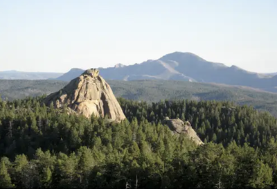
Noddle Heads
Noddle Heads, 8260'. A series of four spires and rock towers in the Pike National Forest northwest of Devil's Head, east of Deckers, and west of the Rampart Range Off-Highway Vehicle area. Good for both hiking and climbing.
There are several access points, all eventually requiring some off-trail travel to reach the spires, which are spread out, south to north.
The Noddle Trail #677 leaves at the Noddles TH (also marked on some maps as the Pike-San Isabel National Forests & Cimarron and Comanche National Grasslands - Sugar Creek Upper Trailhead (usda.gov) located on the west side of CO-67. Approximately three miles south of Sprucewood.
Another access is at closed Forest Rd 518b about a mile south of the Noddles TH on CO-67, at a green gate. The Lower Sugar Creek TH is at the other end of the Noddle Trail (39.301520443689114, -105.17254405693457) and continues across CO-67 to the Log Jumper Trail | COTREX (colorado.gov)
The Noddle Trail is tied into the Rampart Range Recreation Area and is open only 6/16 -11/30. The trail is open to (and wide enough for) Off-Highway Vehicles. Trail access may be closed on additional dates to prevent damage to the trail/roadbed, or because it is not passable due to snow and/or ice. Contact the Pike-San Isabel National Forests & Cimarron and Comanche National Grasslands - South Platte Ranger District - Recreation (usda.gov)
Location - Noddle Heads - Google Maps
- Suitable Activities: Climbing, Hiking
- Snowshoeing Category: Intermediate
- Seasons: June, July, August, September, October, November
- Weather: View weather forecast
- Avalanche Terrain Rating Complex View avalanche forecast.
-
Land Manager:
U.S. Forest Service
South Platte Ranger District (PSINF)
- Parking Permit Required: USFS Permits & Passes
- Recommended Party Size: 12
- Maximum Party Size: 12
- Maximum Route/Place Capacity: 12
- Nat Geo #135
There are no resources for this route/place. Log in and send us updates, images, or resources.
