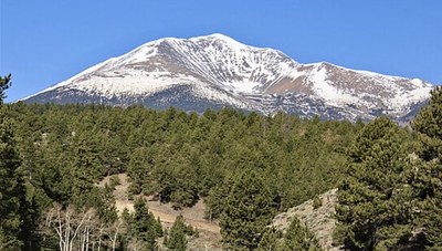
Mt Ouray
Mount Ouray, at 13,979’ is the 4th highest of the 13er Centennial peaks, located on the boundary between Chaffee and Saguache counties. The mountain was named in honor of Ute Chief Ouray.
There are multiple ways to reach the summit. It can be hiked with neighboring
peak Mt Chipeta (named in honor of Chief Ouray’s wife), which adds an extra 2
miles and 800 ft of gain.
Here are some approaches and their locations. All the routes are described in
detail at Summit Post:
The standard route is from the SW starting at the Marshall Pass TH, near where it
intersects with Colorado Trail Segment 16/Continental Divide Trail-Monarch Crest
Trail and Marshall Pass Rd. (CR-200) (38.394934, -106.247) The peak climb is all
off trail. RT 6.4 miles, 3200’ gain. There are bathrooms there. CoTrex link.
East Ridge/Grays Creek Trail (from the east) is an unnumbered trail along the
creek, and then up which on some maps goes up and over the mountain to the
Colorado Trail, passing along the south ridge next to the scooped out “Devil’s
Armchair.” The TH is on Marshall Pass Road (38.43149368067232, -
106.17084486277625). RT 8.2 miles, 4258’ gain. AllTrails link.
Little Cochetopa Trail #1409, starts at the western end of CR-210, Little Cochetopa
Rd. The trail also links after 4.1 miles into the Colorado Trail. You will see the
mountain on your left, south as you proceed. Based on a topo map, choose where
head toward a saddle on a north-south ridge that is just over a mile west of Ouray’s
summit. all off-trail. RT 10 miles, 3700’ gain CoTrex link.
Location of Marshall Pass Road TH - 38°25'53.4"N 106°10'15.0"W - Google Maps
- Suitable Activities: Hiking
- Seasons: May, June, July, August, September, October
- Weather: View weather forecast
- Difficulty: Moderate
- 13,979 ft
-
Land Manager:
Land Manager Varies
Salida Ranger District (PSINF)
- Parking Permit Required: Other
- Recommended Party Size: 12
- Maximum Party Size: 12
- Maximum Route/Place Capacity: 12
There are no resources for this route/place. Log in and send us updates, images, or resources.
