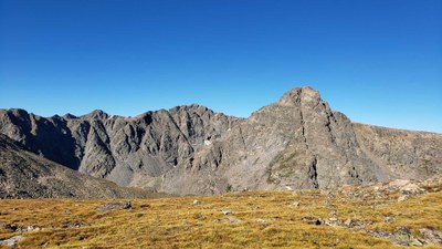
Mt. of the Holy Cross
Popular 14er located just outside of Minturn, CO.
Mt of the Holy Cross via Halo Ridge: 15 miles, 5,210 feet of elevation gain
Unlike the standard route, the Halo Ridge of Holy Cross hikes by four beautiful high alpine lakes and unique Notch Mountain shelter
- Suitable Activities: Hiking
- Seasons: Year-round
- Weather: View weather forecast
- 14,007 ft
-
Land Manager:
U.S. Forest Service
Holy Cross Wilderness Area, Eagle Ranger District (WRNF)
- Parking Permit Required: USFS Permits & Passes
- Recommended Party Size: 12
- Maximum Party Size: 25
- Maximum Route/Place Capacity: 25
This is a list of titles that represent the variations of trips you can take at this route/place. This includes side trips, extensions and peak combinations. Not seeing a title that fits your trip? Log in and send us updates, images, or resources.
- Mt. of the Holy Cross via Halo Ridge
There are no resources for this route/place. Log in and send us updates, images, or resources.
