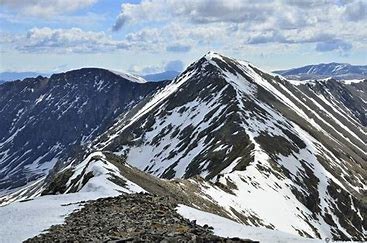
Mt Edwards
Long hike up old jeep road followed by ascending easy off-trail terrain. Edwards sits east of Grays Peak.
Before creating a trip, click “Activities” below to make sure there isn’t already a trip booked to the same place on the same date.
For further information and any restrictions see: Mount Edwards : Climbing, Hiking & Mountaineering : SummitPost
Directions to Trailheads: Gray's & Torrey's Peaks Trailhead - Google Maps
Leavenworth Creek Rd - Google Maps
Alternate title data:
Mt Edwards Loop from Waldorf Mine - 14 mikes - 4200 Elevation Gain
To review the Trip Leader Checklist see: Shared R:P+Trip Leader Activity Checklists - Google Docs
- Suitable Activities: Hiking
- Seasons: Year-round
- Weather: View weather forecast
- Length: 14.0 mi
- Elevation Gain: 13,839 ft
-
Land Manager:
U.S. Forest Service
Clear Creek Ranger District (ARNF)
- Parking Permit Required: USFS Permits & Passes
- Recommended Party Size: 9
- Maximum Party Size: 15
- Maximum Route/Place Capacity: 15
This is a list of titles that represent the variations of trips you can take at this route/place. This includes side trips, extensions and peak combinations. Not seeing a title that fits your trip? Log in and send us updates, images, or resources.
- Mt Edwards - Mt Edwards Loop from Waldorf Mine
There are no resources for this route/place. Log in and send us updates, images, or resources.
