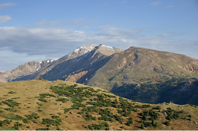
Mount Massive
Mount Massive (14, 427'), which is the 2nd highest peak in Colorado, is appropriately named as it has seven summits over 14,000' with the highest peak at 14,427'.
Mt Massive via East Slope: 14.5 miles, 4,500 feet of elevation gain
After parking in the Mount Massive Parking lot, start the hike at the Mount Massive Trailhead at 10,050'. Start the hike going north on the Colorado Trail that enters into the Mount Massive Wilderness Area. Follow the Colorado Trail for 3 miles with completing the first 1000' gain of the hike. There are three stream crossings on the Colorado Trail with a notable crossing of South Willow Creek at 2.25 miles from the trailhead. Then in a little over 0.5 miles cross Willow Creek which provides a good spot to filter water. After crossing Willow Creek look for the Mount Massive Trail junction that marks the end of the Colorado Trail portion of the route. Follow the Mount Massive Trail section of the route where you will gain around 3500' in 4.2 miles prior to reaching the summit. The trail initially goes through trees before reaching an open space and then enters switchbacks through willows. After the willows, the trail goes above tree-line with coming to a large flat rock at 12,860'. The trail then heads toward the saddle between Mount Massive and South Massive at 13,900'. Turn right at the saddle. From the saddle, the route is less well defined going through steep rock and talus. At 0.75 miles above the saddle, you will reach the junction between the Southwest Slopes Trail where it joins the Mount Massive Trail at 14,250'. Continue to follow cairns and a faint path bearing right as you negotiate a section of Class 2 scrambling up the ridge until easier terrain is reached at the false summit ridge crest at 14,300'. Go over the ridge crest where the summit comes into view. The remainder of the final push to the summit entails less challenging scrambling to the top.
Mt Massive via Southwest Slope: 7.25 miles, 3,950 feet of elevation gain
Getting there:
To reach the Mount Massive Trailhead, from US 24 south of Leadville, turn onto CO 300. Drive 0.7 miles on CO 300 before turning left onto CR 11. Continue 1.2 miles on CR 11 then turn right onto Halfmoon Creek Road that is an easy dirt road accessible with 2WD. Continue 5.3 miles on Halfmoon Creek Road to the Mount Massive parking lot on the right.
Willow Creek Trail
Willow Creek Trail at the base of Mt. Massive with possible views of Mt. Elbert and the Upper Arkansas River Valley.
Starting at the Halfmoon Road winter trailhead, hike/snowshoe up a gentle trail for the first mile. The trail will steepen as you curve to the south and follow the valley alongside the creek. Some route-finding may be necessary about 1.5 miles in. The trail does intersect with the Continental Divide Trail 3.5 miles in.
Traversing private property on a public road is necessary. Stay on the road. Very difficult trail breaking.
- Suitable Activities: Hiking, Scrambling
- Snowshoeing Category: Intermediate
- Seasons: July, August, September, October
- Weather: View weather forecast
- 14,427 ft
-
Land Manager:
U.S. Forest Service
Mount Massive Wilderness Area, Leadville Ranger District (PSINF)
- Parking Permit Required: USFS Permits & Passes
- Recommended Party Size: 12
- Maximum Party Size: 15
- Maximum Route/Place Capacity: 15
This is a list of titles that represent the variations of trips you can take at this route/place. This includes side trips, extensions and peak combinations. Not seeing a title that fits your trip? Log in and send us updates, images, or resources.
- Mt Massive via East Slope
- Mt Massive via Southwest Slope
- Willow Creek Trail
There are no resources for this route/place. Log in and send us updates, images, or resources.
