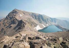
Mount Flora and Mount Eva
Out and back trail from Berthoud Pass. 3,260 ft of elevation, about 10 miles.
From Berthoud Pass (11,315 ft.), follow the Continental Divide Trail to the north and east. The first destination is Mt. Flora, 13,132 ft. From Mt Flora, follow the Continental Divide north to Mt. Eva (13,130’). Then return back over or west of Mt. Flora to Berthoud Pass. Don't underestimate the steep 800' drop to a saddle on the way from Flora to Eva, nor getting up it on the way back. This hike is above tree line almost the entire time, providing nice views all round.
Alternate title -
Mount Flora
Mount Eva
- Suitable Activities: Hiking
- Seasons: June, July, August, September
- Weather: View weather forecast
- Length: 10.0 mi
- Elevation Gain: 3,260 ft
- 13,132 ft
-
Land Manager:
U.S. Forest Service
James Peak Wilderness Area, Clear Creek Ranger District (ARNF)
- Parking Permit Required: USFS Permits & Passes
- Recommended Party Size: 12
- Maximum Party Size: 12
- Maximum Route/Place Capacity: 12
This is a list of titles that represent the variations of trips you can take at this route/place. This includes side trips, extensions and peak combinations. Not seeing a title that fits your trip? Log in and send us updates, images, or resources.
- Mount Flora
- Mount Eva
There are no resources for this route/place. Log in and send us updates, images, or resources.
