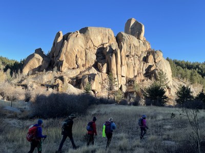
Monument Headwaters from Mount Herman Road
A loop mostly on user-created trails that passes and summits many rock formations, aspen groves, and streams in the Rampart Range. Ideal for fall color and wildflowers. 3 stream crossings.
Much of the route is on Pocket Pals Trail Guide #13. Starting at the intersection of FR320 (Mt Herman Road) and 315, proceed down closed FR322A. As you enter the meadows at the valley bottom, look for a small fence to the right and follow the trail beyond it on the south side of Monument Creek. Ford Monument Creek and continue to follow the trail on the north side. Cross Trail 756 and continue up a tributary to the north on a trail created by dirtbikers. When you reach FR322, turn right and go to the Monument View trail. Proceed to the end of the trail and enjoy a magnificent view of North Monument canyon. Turn back, and at the first gully to the west bushwhack down to and across North Monument Creek (traces of trail will be found). Head upstream and pick up a trail along the north of the creek. When you reach the North Monument Creek trail, cross the creek and proceed up the tributary valley. At FR322, briefly head left to see the original Balanced Rock that the road is named for. Then head west to closed FR322A. This will take you back to the trailhead; at the sharp switchback to the right you can proceed ahead to a rock castle that can be skirted to the east (left).
- Suitable Activities: Hiking
- Seasons: Year-round
- Weather: View weather forecast
- Length: 9.0 mi
- Elevation Gain: 2,000 ft
- 9,200 ft
-
Land Manager:
U.S. Forest Service
Pikes Peak Ranger District (PSINF)
- Parking Permit Required: USFS Permits & Passes
- Recommended Party Size: 12
- Maximum Party Size: 12
- Maximum Route/Place Capacity: 12
There are no resources for this route/place. Log in and send us updates, images, or resources.
