Mestaa’ėhehe Mountain Trail
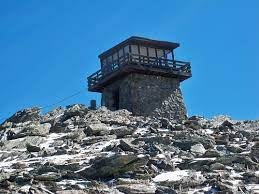
Mestaa’ėhehe Mountain (pronounced mess-taw-HAY) trail is an easy out-and-back. The trail is primarily a wide two-track trail to the top of it where there is a functioning fire tower.
For further information and any restrictions see: Mestaa'ėhehe Mountain : Climbing, Hiking & Mountaineering : SummitPost
Directions to parking lot: Mestaa’Ėhehe Mountain fire lookout - Google Maps
SEASONAL ROAD CLOSURE: Roads leading to this trailhead are subject to seasonal closure due to winter weather conditions. For more information, please visit https://www.fs.usda.gov/detail/arp/home/?cid=fsm91_058362
Mestaa’ėhehe Mountain was renamed at the end of 2022 from Sq**w Mountain. This racially charged term has been a dehumanizing slur against native women for generations. “Renaming is much more than physically changing a sign,” said the Mestaa’ėhehe Coalition. “It is a process of acknowledging the harm and trauma of the past and bridging the way for a peaceful future together.” Mestaa’ėhehe Mountain, located in Arapaho and Roosevelt National Forests, is now named after a prominent Native woman in Colorado history: Mestaa’ėhehe, also known as Owl Woman in the Cheyenne language.
The hike takes participants through beautiful new- and old-growth forest. Generally best enjoyed March - October, this is a very popular area for birding, cross-country skiing, and hiking, so you'll likely encounter other people while exploring. Dogs are welcome, but must be on a leash. This is also a good hike for children or less experienced hikers to get a relatively easy approach for amazing 360 views of mountains both near and far. Chief and Papoose mountains are two 11,000 summits next to Mestaa’ėhehe. These can be combined for a longer hike.
Alternate title data:
Mestaa’ėhehe and Chief Mountain
Mestaa’ėhehe Mountain and Fire Lookout
- Suitable Activities: Hiking, Snowshoeing, Trail Running
- Snowshoeing Category: Basic
- Seasons: Year-round
- Weather: View weather forecast
- Length: 4.1 mi
- Elevation Gain: 861 ft
- 11,431 ft
-
Land Manager:
U.S. Forest Service
Clear Creek Ranger District (ARNF)
- Parking Permit Required: USFS Permits & Passes
- Recommended Party Size: 12
- Maximum Party Size: 15
- Maximum Route/Place Capacity: 15
- All Trails
- CalTopo
This is a list of titles that represent the variations of trips you can take at this route/place. This includes side trips, extensions and peak combinations. Not seeing a title that fits your trip? Log in and send us updates, images, or resources.
- Mestaa’ėhehe Mountain Trail - Mestaa’ėhehe and Chief Mountain
- Mestaa’ėhehe Mountain Trail - Mestaa’ėhehe Mountain and Fire Lookout
There are no resources for this route/place. Log in and send us updates, images, or resources.
