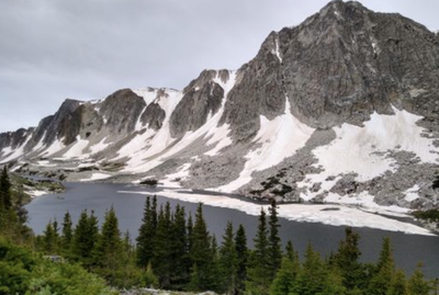
Medicine Bow / Browns Peaks Figure 8 Loop
A figure-8 on-trail route around Medicine Bow Peak (12013') and Browns Peak (11703'), in the Snowy Range outside of Laramie, WY.
This route is a 20-mile figure-8 loop around Browns and Medicine Bow peaks. The route travels at or above tree line for the majority of the trip so be prepared for excellent views, tundra wildflowers, and afternoon thunderstorms. This route can be started from the Sheep Lake Trailhead, along the eastern edge of the figure-8, but other choices exist throughout due to many trailheads/campgrounds. To complete this route you'll combine these two loops - the Alpine Lakes Loop and the Medicine Bow Peak Loop. AllTrails also has detailed info for both loops: Medicine Bow Peak and Browns Peak.
- Suitable Activities: Backpacking, Fly Fishing, Hiking, Trail Running
- Seasons: July, August, September, October
- Weather: View weather forecast
- Avalanche Terrain Rating Challenging View avalanche forecast.
- Difficulty: Challenging
- Length: 20.0 mi
- Elevation Gain: 3,125 ft
- 12,000 ft
-
Land Manager:
U.S. Forest Service
Laramie Ranger District (Medicine Bow-Routt National Forests)
- Parking Permit Required: USFS Permits & Passes
- Recommended Party Size: 12
- Maximum Party Size: 12
- Maximum Route/Place Capacity: 12
- Hiking Project
- Alltrails
There are no resources for this route/place. Log in and send us updates, images, or resources.
