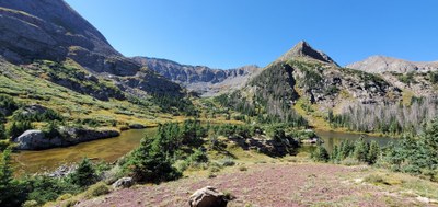
Macey Lakes
The Macey Lakes trail is a challenging, 14 mile out and back with 2,950 feet of elevation gain. The hike starts at the Horn Creek Trailhead, follows the Colorado Trail, then forks to follow Macey Creek, passing Macey Falls, and Copperstain Cliff, ending at three lakes. Those wishing to summit can extend the hike to include Colony Baldy.
Located in the Sangre De Cristo Wilderness these beautiful high mountain lakes are surrounded by lush meadows, cliffs and high mountain peaks. Noted for fishing.
- Suitable Activities: Backpacking, Camping, Exploring Nature, Fly Fishing, Hiking
- Seasons: June, July, August, September
- Weather: View weather forecast
- Difficulty: Diff B
- Length: 16.0 mi
- Elevation Gain: 2,940 ft
- 11,655 ft
-
Land Manager:
U.S. Forest Service
Sangre de Cristo Wilderness Area, San Carlos Ranger District (PSINF)
- Parking Permit Required: USFS Permits & Passes
- Recommended Party Size: 12
- Maximum Party Size: 12
- Maximum Route/Place Capacity: 12
- AllTrails
- COTREX
- caltopo
- Gaia
This is a list of titles that represent the variations of trips you can take at this route/place. This includes side trips, extensions and peak combinations. Not seeing a title that fits your trip? Log in and send us updates, images, or resources.
- Lower and Upper Macey Lakes Via Rainbow Trail
- Macey Trail #1341 via Trail #1336 starting at the Horn Creek Trailhead
There are no resources for this route/place. Log in and send us updates, images, or resources.
