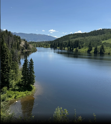
Lower Cataract Loop Trail
Beautiful easy loop around the shoreline of Lower Cataract Lake in the Eagle Next Wilderness Area. On the west end of the lake, there is waterfall from the drainage basin north of Eagle Nest Peak.
This easy and beautiful hike is great for summer wildflowers, waterfowl, wildlife and fall colors. It is about 17 miles north of Silverthorne. It can be difficult to reach in the winter if the road is not plowed. The Loop Trail around Cataract Lake in USFS #57.
For more information:
COTrex (including a map) - https://trails.colorado.gov/trails/cataract-lake-loop-17561
US Forest Service: https://www.fs.usda.gov/recarea/whiteriver/recreation/hiking/recarea/?recid=40947&actid=50
Eagles Nest Wilderness Rules: https://www.fs.usda.gov/Internet/FSE_DOCUMENTS/fseprd637853.pdf
Alltrails - https://www.alltrails.com/trail/us/colorado/lower-cataract-loop-trail
- Suitable Activities: Hiking
- Seasons: May, June, July, August, September, October
- Weather: View weather forecast
- Difficulty: Easy to Moderate, Easy
- Length: 2.3 mi
- Elevation Gain: 223 ft
- 8,749 ft
-
Land Manager:
U.S. Forest Service
Eagles Nest Wilderness Area, Dillon Ranger District (WRNF)
- Parking Permit Required: USFS Permits & Passes
- Recommended Party Size: 12
- Maximum Party Size: 15
- Maximum Route/Place Capacity: 15
- Alltrails
- COTREX
There are no resources for this route/place. Log in and send us updates, images, or resources.
