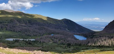
Lakes of The Clouds
Moderately challenging, 10 miles roundtrip, 2,434' elevation gain. Located within the Sangre De Cristo Wilderness.
A beautiful trail leading to three lakes, with an option of going higher to see waterfalls and high mountain tarns. Trail follows Swift Creek to the lowest lake.
From Pueblo drive West on CO-96 50 miles, turn left on Hermit Ln, 2/ m, turn right on Hermit Rd 6.1m, continue straight on to North Taylor Rd. to the Gibson Creek TH at 2270 CO Rd 172, Westcliffe, CO
This trail can be found on AllTrails and CoTrex
- Suitable Activities: Backpacking, Fly Fishing, Hiking
- Seasons: May, June, July, August, September, October
- Weather: View weather forecast
- Difficulty: Diff B
- Length: 10.0 mi
- Elevation Gain: 2,500 ft
- 11,500 ft
-
Land Manager:
U.S. Forest Service
Sangre de Cristo Wilderness Area, Saguache Ranger District (RGNF)
- Parking Permit Required: USFS Permits & Passes
- Recommended Party Size: 12
- Maximum Party Size: 12
- Maximum Route/Place Capacity: 12
- AllTrails
- COTREX
This is a list of titles that represent the variations of trips you can take at this route/place. This includes side trips, extensions and peak combinations. Not seeing a title that fits your trip? Log in and send us updates, images, or resources.
- Lakes of The Clouds via Swift Creek
There are no resources for this route/place. Log in and send us updates, images, or resources.
