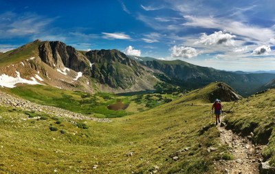
High Lonesome Trail
This trail is coincident with a portion of the Continental Divide Trail. One way from Monarch Lake to the junction with the Corona Trail is 17.8 miles. Note closure July 7, 2023 due to the Devil's Thumb Fire.
The first section of the High Lonesome Trail (USFS #7) goes up to Strawberry Bench, through dead Lodgepole Pine, before levelling out. Some sections are coincident briefly with old roads and an active OHV use area, before approaching the Junco Lake Trailhead. No water available along the trail.
Location of TH - High Lonesome Trailhead - Google Maps
Via the Monarch Lake Trailhead: Take Highway 34 to County Road 6, 5.4 miles north of Granby and 8.9 miles south of Grand Lake. County Road 6 (NFSR 125) is a 9.4 miles improved road along Granby Reservoir to Monarch Lake where parking is available. • Via the Junco Lake Trailhead: There is also a mid access by taking Highway 40 to County Road 83, just outside of the town of Tabernash. County Road 83 soon forks. Take a left at the fork, continue about 9 miles to Meadow Creek Reservoir from Highway 40. Continue around the east side of the reservoir for 3 miles to the High Lonesome TH. This is useful for hiking, bicycling and horse riding, with good trailer parking at the trailhead. • Via the Devil’s Thumb Park Trailhead: Take US Highway 40 to the North side of the Town of Fraser, to County Road 8. Follow this residential, paved route, until it turns to dirt and forks with County Road 81. Continue straight ahead on this County Road is a primitive dirt road through the Forest, heading North. It will eventually become Forest Road 128, which is also known as the Waterboard Road.This is a windy road, with some steep ups and downs. It is only 1 mile from the Forest Boundary to NFSR 128.2C, which is the access to the Devil’s Thumb Park Trailhead. Please note that this Trailhead is very tight. Trailers are not recommended here.
- Suitable Activities: Hiking
- Seasons: July, August, September
- Weather: View weather forecast
- Avalanche Terrain Rating Complex View avalanche forecast.
- Difficulty: Difficult
- Length: 18.0 mi
- Elevation Gain: 3,742 ft
- 12,111 ft
-
Land Manager:
U.S. Forest Service
Sulphur Ranger District (ARNF)
- Parking Permit Required: USFS Permits & Passes
- Recommended Party Size: 12
- Maximum Party Size: 12
- Maximum Route/Place Capacity: 12
- COTREX
This is a list of titles that represent the variations of trips you can take at this route/place. This includes side trips, extensions and peak combinations. Not seeing a title that fits your trip? Log in and send us updates, images, or resources.
- Via the Monarch Lake Trailhead: Take Highway 34 to County Road 6, 5.4 miles north of Granby and 8.9 miles south of Grand Lake. County Road 6 (NFSR 125) is a 9.4 miles improved road along Granby Reservoir to Monarch Lake where parking is available. • Via the Junco Lake Trailhead: There is also a mid access by taking Highway 40 to County Road 83, just outside of the town of Tabernash. County Road 83 soon forks. Take a left at the fork, continue about 9 miles to Meadow Creek Reservoir from Highway 40. Continue around the east side of the reservoir for 3 miles to the High Lonesome TH. This is useful for hiking, bicycling and horse riding, with good trailer parking at the trailhead. • Via the Devil’s Thumb Park Trailhead: Take US Highway 40 to the North side of the Town of Fraser, to County Road 8. Follow this residential, paved route, until it turns to dirt and forks with County Road 81. Continue straight ahead on this County Road is a primitive dirt road through the Forest, heading North. It will eventually become Forest Road 128, which is also known as the Waterboard Road.This is a windy road, with some steep ups and downs. It is only 1 mile from the Forest Boundary to NFSR 128.2C, which is the access to the Devil’s Thumb Park Trailhead. Please note that this Trailhead is very tight. Trailers are not recommended here.
There are no resources for this route/place. Log in and send us updates, images, or resources.
