Hells Hole
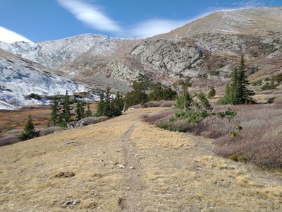
The Hells Hole trail follows West Chicago Creek up to a glacial cirque. This hike is 8 miles out and back with about 1,900 feet of elevation gain.
The trail climbs at a steady pace for 4 miles and passes through a large grove of aspen trees, which makes it a great fall hike. Much of the hike is in the trees but when the trail reaches Hell's Hole there is an open meadow with alpine willows and bristlecone trees.
A mandatory free self-issuing permit is required for the Mount Evans Wilderness. Free permits are available at each trailhead or entry point into the wilderness.
Please refer to the current restrictions and details regarding this location. https://www.fs.usda.gov/recarea/arp/recarea/?recid=28432
Reach the TH at West Chicago Creek Campground. Leave I-70 at Idaho Springs exit #240. Follow Hwy 103 south for 6.5 miles and turn right on West Chicago Creek Road. Go 3 miles to the campground.
- Suitable Activities: Hiking, Snowshoeing
- Snowshoeing Category: Basic
- Seasons: Year-round
- Weather: View weather forecast
- Difficulty: Mod B
- Length: 8.0 mi
- Elevation Gain: 1,900 ft
- 11,522 ft
-
Land Manager:
U.S. Forest Service
Mount Evans Wilderness Area, South Platte Ranger District (PSINF)
- Parking Permit Required: USFS Permits & Passes
- Recommended Party Size: 12
- Maximum Party Size: 15
- Maximum Route/Place Capacity: 15
There are no resources for this route/place. Log in and send us updates, images, or resources.
