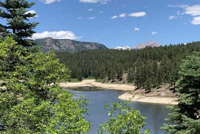
Haviland Lake Trail
This flat, forested hiking area is just south of Haviland Lake and is adjacent to a campground. There are a number of possible loops allowing a longer or shorter trip as desired.
The summer TH is located at the south end of the lake near the Haviland Lake Campground: 37.53291, -107.80563. There are restrooms at this TH.
In winter, parking and snowshoe access are available right off CO-550 at 37.53291, -107.80563.
Location of TH - Haviland Lake Campground - Google Maps
Alternate titles -
Haviland Lake Loop
- Suitable Activities: Backcountry Nordic Skiing, Hiking, Snowshoeing
- Snowshoeing Category: Beginner
- Seasons: May, June, July, August, September
- Weather: View weather forecast
- Difficulty: Easy
- Length: 6.0 mi
- Elevation Gain: 550 ft
- 8,250 ft
-
Land Manager:
U.S. Forest Service
Columbine Ranger District (SJNF)
- Parking Permit Required: USFS Permits & Passes
- Recommended Party Size: 12
- Maximum Party Size: 12
- Maximum Route/Place Capacity: 12
- AllTrails
- CoTrex
This is a list of titles that represent the variations of trips you can take at this route/place. This includes side trips, extensions and peak combinations. Not seeing a title that fits your trip? Log in and send us updates, images, or resources.
- Haviland Lake Trail - Haviland Lake Loop
There are no resources for this route/place. Log in and send us updates, images, or resources.
