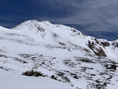
Hagar Mountain
Hager Mountain is a classic 13-er on the Continental Divide
Before creating a trip, click “Activities” below to make sure there isn’t already a trip booked to the same place on the same date.
For further information and any restrictions see: Hagar Mountain : Climbing, Hiking & Mountaineering : SummitPost
Directions to parking lot: Herman Gulch Trailhead - Google Maps
Alternate title data:
Hagar Mountain from Herman Gulch
Hagar Mountain from Dry Gulch
Hagar Mountain (13220 ft) can be climbed in conjunction with local peaks to add mileage and elevation. Most of the hike is Class 2 but the scramble to access the summit is a Class 3. The route follows the right side of the ridge.
To review the Trip Leader Checklist see: Shared R:P+Trip Leader Activity Checklists - Google Docs
- Suitable Activities: Hiking, Scrambling, Ski Mountaineering
- Seasons: Year-round
- Weather: View weather forecast
- View avalanche forecast.
- Difficulty: Moderately Difficult Class D
- 13,220 ft
-
Land Manager:
U.S. Forest Service
White River Field Office, Clear Creek Ranger District (ARNF)
- Parking Permit Required: USFS Permits & Passes
- Recommended Party Size: 9
- Maximum Party Size: 10
- Maximum Route/Place Capacity: 10
This is a list of titles that represent the variations of trips you can take at this route/place. This includes side trips, extensions and peak combinations. Not seeing a title that fits your trip? Log in and send us updates, images, or resources.
- Hagar Mountain via Dry Creek
- Hagar Mountain and Citadel
- Hagar Mountain via Golden Bear
- Hagar Mountain via Trelease and Golden Bear
There are no resources for this route/place. Log in and send us updates, images, or resources.
