Grizzly Peak D, Loveland Pass
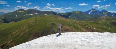
Grizzly Peak on the east side of Loveland Pass is a solid Class 2 hike over mostly tundra terrain with a rocky finish. The trailhead is Loveland Pass. Grizzly combines well with Mount Sniktau and Cupid for a short, triple-header day.
For further information see: Grizzly Peak : Climbing, Hiking & Mountaineering : SummitPost
From the summit of Loveland Pass, walk uphill to the NE along the very well-used trail that leads up to Pt. 12,915. Continue North over well-defined trail to Mount Sniktau’s summit. This last section becomes rockier, but still has well-defined trail. Return to Pt. 12,915, then continue hiking SE toward Cupid and Grizzly.
From Pt. 12,915 a trail continues along the ridge to the SSE for the .9 mile to Cupid Peak. Drop about 200 feet in elevation to the saddle, then regain 400 feet to the Cupid summit. The terrain is mostly broad tundra slopes with large rocks scattered around.
From the summit of Cupid Peak, walk south down along the ridge crest, losing close to 350 feet in elevation to the first saddle. There is still a well-defined trail that cuts mostly through tundra. At one point, the trail drops you onto the east side of the ridge, then regains the ridge. The tundra will continue most of the way to the base of the final ascent section to Grizzly. You will need to ascend to Pt. 12,936, then lose another 100 feet in elevation before you reach the final ascent of nearly 700 vertical feet. It is on this last stretch that you will encounter more rock - that is broken rubble, talus, etc. The trail will become more faint and several possible paths may become options. When you arrive at the summit, Torreys Peak will seem to loom above you, still 700 vertical feet higher, and Grays will be seen just a little farther away. Grizzly Peak sits at the head of Chihuahua Gulch to the south.
- Suitable Activities: Hiking
- Climbing Category: Basic Alpine Climb
- Seasons: Year-round
- Weather: View weather forecast
- View avalanche forecast.
- Difficulty: Easy C
- Length: 8.3 mi
- Elevation Gain: 3,500 ft
- 13,427 ft
-
Land Manager:
U.S. Forest Service
Dillon Ranger District (WRNF)
- Parking Permit Required: USFS Permits & Passes
- Recommended Party Size: 12
- Maximum Party Size: 12
- Maximum Route/Place Capacity: 12
This is a list of titles that represent the variations of trips you can take at this route/place. This includes side trips, extensions and peak combinations. Not seeing a title that fits your trip? Log in and send us updates, images, or resources.
- Grizzly Peak - Grizzly Peak A
There are no resources for this route/place. Log in and send us updates, images, or resources.
