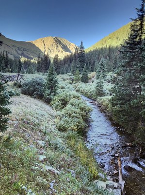
Grizzly Gulch Trailhead
This gulch lies between Kelso Mountain, Gray's and Torrey's Peaks to the east, with Mt Baker, Kearney Gulch, and then Mt Sniktau to the west. Hikers are rewarded with a beautiful stream and views at the top of the gulch, which approaches the Continental Divide.
Easy access from I-70 Exit 221, Bakerville. Cross under the freeway, then over Bakerville Rd. to enter a cleared area used for parking. Walk about a mile up Stevens Gulch Rd CR-321 and then turn right onto the Grizzly Gulch trail, CR-321/FSR-189-1C. Toward the end, on the slopes up to the Divide, the trail disappears into alpine terrain. Grizzly Peak and Cupid can be summited from here.
The TH also serves as the Gray's and Torrey's winter/lower TH.
Stevens Gulch Road is very rocky. It becomes inaccessible during the winter and is subject to seasonal closure. Beware of avalanche danger even if the road is open.
- Suitable Activities: Hiking
- Seasons: June, July, August, September, October
- Weather: View weather forecast
- Avalanche Terrain Rating Complex View avalanche forecast.
-
Land Manager:
U.S. Forest Service
Clear Creek Ranger District (ARNF)
- Parking Permit Required: USFS Permits & Passes
- Recommended Party Size: 12
- Maximum Party Size: 15
- Maximum Route/Place Capacity: 15
This is a list of titles that represent the variations of trips you can take at this route/place. This includes side trips, extensions and peak combinations. Not seeing a title that fits your trip? Log in and send us updates, images, or resources.
- Grizzly Gulch TH to Baker Mountain
- Grizzly Gulch TH to Kelso Mountain
- Grizzly Gulch TH to Grizzly Peak Trail/Grizzly Peak D summit
- Grizzly Gulch TH to Cupid Peak
- Grizzly Gulch TH to Bakerville-Loveland Trail
There are no resources for this route/place. Log in and send us updates, images, or resources.
