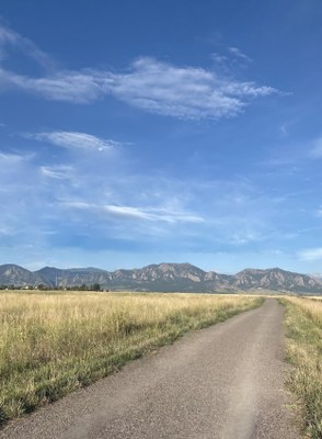
Greenbelt Plateau Trailhead
Greenbelt Plateau and High Plains Trails start directly from this TH, providing access to numerous other trails, including the Community Ditch and Flatirons Vista areas.
There is a parking lot at this trailhead but no restrooms or picnic tables. Note that free parking is available on BOTH sides of McCaslin Boulevard as well.
Alternate Titles, accessed directly from this TH are:
Greenbelt Plateau Trail - 4.7 miles, 262' gain
High Plains Trail - 2.7 miles, 163' gain
Make a longer hike with these connecting trails: Flatirons Vista North, Flatirons Vista South, Community Ditch, Marshall Mesa, Coal Seam, Coalton, and Prairie Vista.
- Suitable Activities: Hiking, Biking, Trail Running, Exploring Nature, Family, Photography
- Seasons: Year-round
- Weather: View weather forecast
- Difficulty: Easy
- 5,908 ft
- Land Manager: Boulder
- Parking Permit Required: Other
- Recommended Party Size: 12
- Maximum Party Size: 12
- Maximum Route/Place Capacity: 12
- CoTrex
- Boulder
- AllTrails
- hikingproject
- trailforks
This is a list of titles that represent the variations of trips you can take at this route/place. This includes side trips, extensions and peak combinations. Not seeing a title that fits your trip? Log in and send us updates, images, or resources.
- Greenbelt Plateau TH - Greenbelt Plateau Trail
- Greenbelt Plateau TH - High Plains Trail
There are no resources for this route/place. Log in and send us updates, images, or resources.
