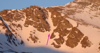
Gray's Peak
This route will take you either to Gray's Peak or Torrey's Peak. There is considerable exposure, rock fall, and commitment.
Before creating a trip, click “Activities” below to make sure there isn’t already a trip booked to the same place on the same date.
For further information and any restrictions see: Grays Peak : Climbing, Hiking & Mountaineering : SummitPost
Torreys Peak : Climbing, Hiking & Mountaineering : SummitPost
Arapaho & Roosevelt National Forests Pawnee National Grassland - Home (usda.gov)
Directions to trailhead: Grays Peak Trail, Dillon, CO - Google Maps
Alternate title data:
Gray's Peak - Lost Rat Couloir - 7.3 miles - 3005 ft Elevation Gain
Torrey's Peak - 8.1 miles - 3605 ft Elevation Gain
Gray's Peak - Lost Rat Couloir Information
From the summer trailhead, cross the bridge that spans the stream in Stevens Gulch and follow the well-defined Grays trail up the hill into Stevens Gulch. Continue on the Grays trail for nearly 1.5 miles until you are near the trail sign near 12,100'. Just before the sign, locate a small road that leaves the left side of the Grays trail. Follow the small road down a bit and then south towards the center of the basin. After heading south for a bit, continue on the road as you approach the southwest end of the basin. Stay on or near the road as it climbs onto the talus below Lost Rat. Hike over to the base of the couloir. Crampons, axe, helmet, and avalanche gear are recommended.
Start climbing. Above 12,800', the terrain steepens as you approach the confines of the couloir. Above 13,100', reach a fork in the couloir. Stay left and continue up the main couloir. The next 300 feet is straightforward and the slope angle reaches 45 degrees, avg is 40 degrees. Near 13,500', the couloir turns slightly left as you pass through the narrowest section. Climb the last 100 feet to reach the top of Lost Rat. Turn right (west) to see the remaining 700 feet up Grays' east ridge. The couloir melts out at the top so be prepared for a scree finish. Follow the ridge to the summit. Return on the standard Grays trail.
- Suitable Activities: Mountaineering, Hiking, Climbing
- Climbing Category: Intermediate Alpine Climb
- Seasons: April, May, June
- Weather: View weather forecast
- Avalanche Terrain Rating Challenging View avalanche forecast.
-
Land Manager:
U.S. Forest Service
Clear Creek Ranger District (ARNF)
- Parking Permit Required: USFS Permits & Passes
- Recommended Party Size: 12
- Maximum Party Size: 12
- Maximum Route/Place Capacity: 12
- https://caltopo.com/m/7HEU6
This is a list of titles that represent the variations of trips you can take at this route/place. This includes side trips, extensions and peak combinations. Not seeing a title that fits your trip? Log in and send us updates, images, or resources.
- Gray's Peak - Lost Rat Couloir
- Gray's Peak - Torrey's Peak
- Gray's and Torrey's Peaks
There are no resources for this route/place. Log in and send us updates, images, or resources.
