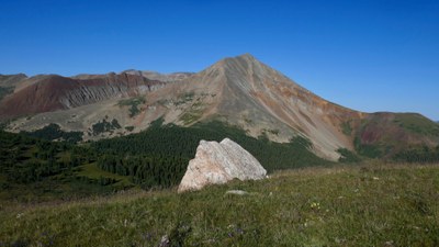
Glacier Peak via Georgia Pass
This is a beautiful with views of Mt. Guyot, South Park & more.
For further information see: Glacier Peak | U.S. Geological Survey (usgs.gov)
From Georgia Pass, hike 0.75 miles on a 4WD road. The Colorado Trail will cross the road midway. Hike through an opening in a long wooden fence. The remaining 2.2 miles of the hike follows the Continental Divide Trail and is on a broad tundra ridge with a few false summits, the last one is particularly steep. Glacier Peak comes into view at the top of the last false summit to the South and looks like a "striped" knoll with streaks of black "rock rivers" running down it's sides. Skirt around the knoll and then climb off trail to the top there is a USGS Benchmark at the top (12,854'). In the summer there are quite a few wildflowers.
- Suitable Activities: Hiking
- Seasons: July, August, September
- Weather: View weather forecast
- Length: 5.8 mi
- Elevation Gain: 1,500 ft
- 12,854 ft
-
Land Manager:
U.S. Forest Service
South Park Ranger District (PSINF)
- Parking Permit Required: USFS Permits & Passes
- Recommended Party Size: 12
- Maximum Party Size: 15
- Maximum Route/Place Capacity: 15
There are no resources for this route/place. Log in and send us updates, images, or resources.
