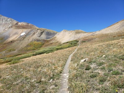
French Pass
Starting in Pike NF/Park County at 10,520, the pass is at 12,640 on the border with White RiverNF/Summit County.
French Pass lies on the mountain border between Breckenridge and Jefferson, west of Georgia Pass, between Mt. Guyot and Bald Mountain. Per the US Geological Survey, the elevation is 12,050, although personal GPS instruments will vary.
Below describes summer hikes from each side at an easy pace of 1.5 to 2 miles an hour. The hike from Breckenridge takes about 7 hours for 12 miles RT while the hike from Jefferson side takes about 6 hours for 7 miles RT. One approach is longer while the other is steeper.
From Breckenridge, take the French Gulch Road (CO 450 south of town) to its dead end and TH parking - elevation 10,280’. This TH also serves Sallie Barber Mine and Sisters Cabin.
Travel up a road past 12 cabins reaching a forest trail (Rt 2) that is marshy at first in the Spring. Therefore, it’s better to do this hike in the early Fall. The marshy area is short and then the trail alternates between meadows and trees until past timberline. The trail is well-trodden and gets steeper near the top.
From Jefferson, take CO 35 west. At 2.8 mi take R fork onto CO 54. At 5.2 m take L turn toward Georgia Pass and Michigan Creek campground. At 8.2 m there is a large open area. Park on the left (no TH signs) – elevation 10,100’.
After 1 hr 15 minutes of gently rising terrain, you come to a small meadow where the trail descends fairly steeply to a steam that might be difficult to cross in the Spring. The trail then climbs steeply from the stream for about 10 minutes and continues a steady climb, sometimes through bushes, all the way to the Pass.
Location of TH: French Pass Trailhead - Google Maps
French Pass: 9 miles, 1,900 feet of elevation gain
French Pass trail provides access to the Continental Divide between Bald Mountain and Mount Guyot. The trail is not always easy to follow and isn't well signed. From the southern trailhead, it leads up the French Creek drainage, beginning at approximately 10,520 feet in elevation. Within 4.5 miles hikers reach the summit of French Pass. The trail continues into the White River National Forest. In the 1860s, this was the original wagon trail access from Denver to the Breckenridge Gold Diggings.
Alternate titles:
French Gulch: 7.2 miles, 1646 ft elevation gain
- Suitable Activities: Backpacking, Hiking, Nordic Skiing, Snowshoeing
- Seasons: Year-round
- Weather: View weather forecast
- Difficulty: Easy
- 12,640 ft
-
Land Manager:
U.S. Forest Service
South Park Ranger District (PSINF)
- Parking Permit Required: USFS Permits & Passes
- Recommended Party Size: 12
- Maximum Party Size: 12
- Maximum Route/Place Capacity: 12
This is a list of titles that represent the variations of trips you can take at this route/place. This includes side trips, extensions and peak combinations. Not seeing a title that fits your trip? Log in and send us updates, images, or resources.
- French Pass - French Gulch
There are no resources for this route/place. Log in and send us updates, images, or resources.
