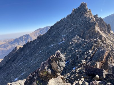
Desolation peaks
The East and West Desolation peaks are located in the remote Mummy range of the northern part of Rocky Mountain National Park. They feature off-trail hiking and scrambling .Access is generally from the Chapin Creek trailhead.
Please view this document with everything you need to know about Rocky Mountain National Park
Class 3 scrambling is required to summit these peaks.
Location of TH - Chapin Creek Trailhead - Google Maps
To get to the Chapin Pass Trailhead, you can enter RMNP from the Fall River Entrance, just North of Estes Park on Hwy 34. On the Western end of Horseshoe Park, take a right towards Old Fall River Rd. This is a one way dirt road that ultimately connects with Trail Ridge Road at the Alpine Visitor Center.
At around mile marker 6, you will come to the Chapin Pass Trailhead (clearly marked). Follow the signs to Ypsilon Mountain. Keep going, about another 1.5 miles, past Ypsilon until you get to the base of West Desolation.
Alternate titles -
Desolation peaks - RMNP
- Suitable Activities: Scrambling
- Seasons: Year-round
- Weather: View weather forecast
- Length: 15.0 mi
- 12,949 ft
- Land Manager: National Park Service
- Parking Permit Required: National Park Entrance Fees
- Recommended Party Size: 12
- Maximum Party Size: 12
- Maximum Route/Place Capacity: 12
This is a list of titles that represent the variations of trips you can take at this route/place. This includes side trips, extensions and peak combinations. Not seeing a title that fits your trip? Log in and send us updates, images, or resources.
- Desolation peaks - RMNP
There are no resources for this route/place. Log in and send us updates, images, or resources.
