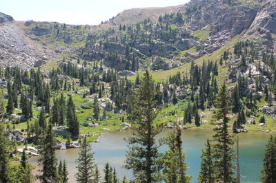
Columbine Lakes via Caribou Pass
This is a great 6.3-mile out-and-back trail with roughly 1,000ft of elevation gain, near Tabernash, Colorado. Columbine Lake is at the top and chances of seeing moose along the way.
Please view this document with everything you need to know about Indian Peaks Wilderness
Note: Groups of 8 or more require day use permit. Overnight stays require permit June 1st thru Sept 15. Link below.
Getting there:
This hike starts at the Junco Lake Trailhead in the Arapaho National Forest but quickly crosses the CDT into the Indian Peaks Wilderness. Trailhead parking is usually available, but does require a $5 day use fee per vehicle which is easily purchased at multiple pay stations along the way. The last pay station (credit cards only) is at 40.022372°N 105.807°W and is likely your last opportunity for cell service. Other passes are accepted, see FS link below for details. Meadow Creek Road (FS129) can easily be driven with a basic AWD vehicle. 2WD is possible but I would not recommend it. Bathroom is available at trailhead.
As always bring your 10 essentials. Most notably I'd highly recommend bug spray, sun screen, and a rain jacket. Dogs are welcome but must be kept on a leash.
Helpful Links
https://www.alltrails.com/trail/us/colorado/columbine-lake-trail--2
https://trails.colorado.gov/trailheads/junco-lake-993
https://www.fs.usda.gov/recarea/arp/recarea/?recid=28552
https://www.recreation.gov/permits/4675318
- Suitable Activities: Backpacking, Camping, Hiking, Photography
- Seasons: June, July, August, September
- Weather: View weather forecast
- Difficulty: Moderate A
- Length: 6.3 mi
- Elevation Gain: 1,046 ft
- 11,200 ft
-
Land Manager:
U.S. Forest Service
Indian Peaks Wilderness Area, Sulphur Ranger District (ARNF)
- Parking Permit Required: USFS Permits & Passes
- Recommended Party Size: 7
- Maximum Party Size: 12
- Maximum Route/Place Capacity: 12
- AllTrails
- COTREX
There are no resources for this route/place. Log in and send us updates, images, or resources.
