Castlewood Canyon State Park
The trails in Castlewood Canyon State Park range from .5 to 4 miles and can be combined for longer journeys. The most popular trailheads are the Castlewood Canyon State Park Visitor Center (accessed off of Hwy 83 south of Franktown) or the Westside Trailhead (on Castlewood Canyon Road)
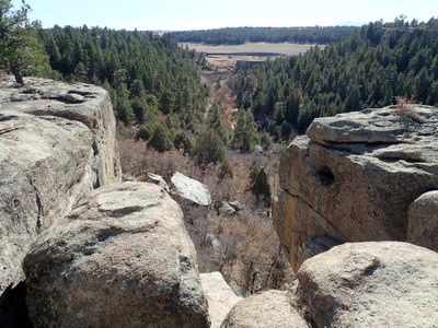
The winding Cherry Creek flowing along the canyon floor provides wonderful views and rest stops. Some of the trails also provide views of the canyon from the canyon rim. Remnants of geologic and local history combine when the then Castlewood Dam burst in 1933, sending a 15-foot-high wave of water into Denver. Ruins of the original ill-fated dam and the historic homestead still exist for hikers to see.
Double Loop Hike: 9 miles, 1,100 feet of elevation gain.
The hike has views of Cherry Creek from the canyon floor, the canyon rim, as well as views of Castlewood Dam ruins. There are options for shorter hikes in the state park.
Climbing: 300 routes including 100 sport routes
- Suitable Activities: Climbing, Hiking
- Climbing Category: Crag Rock Climb
- Seasons: Year-round
- Weather: View weather forecast
- Elevation Gain: 1,100 ft
- 6,600 ft
-
Land Manager:
Colorado Parks & Wildlife
Castlewood Canyon State Park
- Parking Permit Required: State Parks Entrance Fee / Pass
- Recommended Party Size: 12
- Maximum Party Size: 30
- Maximum Route/Place Capacity: 30
- AllTrails
- COTREX
- caltopo
- Gaia
This is a list of titles that represent the variations of trips you can take at this route/place. This includes side trips, extensions and peak combinations. Not seeing a title that fits your trip? Log in and send us updates, images, or resources.
- Castlewood Canyon - Visitor Center
- Castlewood Canyon - Westside Trailhead
There are no resources for this route/place. Log in and send us updates, images, or resources.
