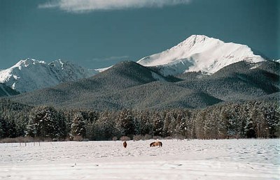
Byers Peak - North Ridge
This is a 13 mile RT hike, up to class 3 terrain, 4,140 feet of elevation gain, max elevation 12,804. This is located in Byers Peak Wilderness with Byers Peak being the tallest peak in the wilderness.
In the winter, the route for Byers Peak follows a ~5 mile one way road hike starting from St Louis Creek Trailhead.
At the end of the road. You will go off trail heading west until reaching the ridgeline where you will continue off trail up the ridge until getting above treeline.
The ridgeline contains some class 3 scrambling sections along with "cornices, reminiscent of Alaska"
- Suitable Activities: Mountaineering
- Climbing Category: Intermediate Alpine Climb
- Seasons: Year-round
- Weather: View weather forecast
- Avalanche Terrain Rating Simple View avalanche forecast.
- Length: 13.0 None
- Elevation Gain: 4,140 ft
- 12,804 ft
-
Land Manager:
U.S. Forest Service
Byers Peak Wilderness Area, Sulphur Ranger District (ARNF)
- Parking Permit Required: USFS Permits & Passes
- Recommended Party Size: 6
- Maximum Party Size: 12
- Maximum Route/Place Capacity: 12
There are no resources for this route/place. Log in and send us updates, images, or resources.
