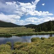
Buffalo Peaks Wilderness
This wilderness area is located 15 miles southwest of Fairplay, is named for two 13,000+ eroded volcanos.
For further information and any restrictions see: Pike-San Isabel National Forests & Cimarron and Comanche National Grasslands - Buffalo Peaks Wilderness (usda.gov)
Trailhead access from Highway 285 (east) near Fairplay, Colorado:
- Weston Pass Road (Forest Service Road 22) - Rich Creek Trailhead
- Forest Service Road 431 - Lynch Creek and Buffalo Peaks Trailheads
- Forest Service Road 435 - North Salt Creek Trailhead
Trailhead access from Highway 24 (west) near Buena Vista and Granite Colorado is 4-wheel drive only:
- End of Hayden Gulch Road (Forest Service Road 396) - 4-wheel drive access only.
- End of Low Pass Road (Forest Service Road 149) - 4-wheel drive access only.
- Four Mile Trailhead (Chaffee County Road 375) - 4-wheel drive necessary for last 1 mile of road
- Suitable Activities: Hiking
- Seasons: Year-round
- Weather: View weather forecast
- Avalanche Terrain Rating Simple View avalanche forecast.
-
Land Manager:
U.S. Forest Service
Buffalo Peaks Wilderness Area, South Platte Ranger District (PSINF)
- Parking Permit Required: USFS Permits & Passes
- Recommended Party Size: 12
- Maximum Party Size: 15
- Maximum Route/Place Capacity: 12
This is a list of titles that represent the variations of trips you can take at this route/place. This includes side trips, extensions and peak combinations. Not seeing a title that fits your trip? Log in and send us updates, images, or resources.
- Buffalo Peaks Wilderness - Rich Creek Trail
- Buffalo Peaks Wilderness - Buffalo Meadows
- Buffalo Peaks Wilderness - Ruby Lake
- Weston Pass
- Sheep Creek Trail
- Buffalo Peaks Loop
- Salt Creek Trail
- Twelve Mile Lake
There are no resources for this route/place. Log in and send us updates, images, or resources.
