BPX 3-Day: Seven Lakes from Big Creek Lakes
This is an out and back, moderately difficult, trail to seven alpine lakes in the Mount Zirkel Wilderness area. The trip starts at the Seven Lakes TH at west end of Big Creek Lakes Campground. The trail is 12.6 miles and has 2,300 feet elevation gain RT and optional hiking to 11,800 feet high point on divide of 6.0 miles and 2,000 elevation gain RT.
The first one mile is an interpretive trail which leads to upper Big Creek Lake. The 2016 Beaver Creek Fire burned over 38,000 acres, including the first three miles along this trail. A juvenile was charged with the arson in connection with starting the fire at the nearby Beaver Creek primitive camping area. The forest service has cleared dangerous trees near the trail, but caution should be used during high winds. The standing burned trees are quite beautiful, many with the charred bark peeled back and leaving contrasting color stripes. Many flowers grow in the sunlight areas and wildlife has returned -– watch for moose, bear, osprey and bald eagles. The upper Big Creek Lake is only a short distance off the trail and a good place for a break and bird viewing.
Suggested Backpacking Section (BPX) itinerary for 3-day trip to be used for CMC trips led by BPX leaders for BPX members.
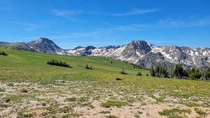
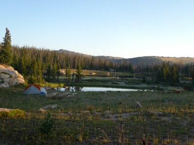
Day 1 – There is plenty of water first 3 miles before switchbacks and then none for next 2 miles or so until spring on the level section before climb to the lakes with ample water. At 1 ¼ miles from TH there is short spur trail to left that leads to the upper Big Creek lake and a nice spot for short break. Approximately 2 1/4 miles from the TH is the Mount Zirkel Wilderness Area boundary and Big Creek Falls which is a good lunch stop. The next ¾ mile is relatively flat before hitting the end of the burn area and starting the big climb up to the high country. Get water by log crossing small creek before climb. Take a well-deserved rest at the top of the switchbacks and enjoy the view out to North Park and the nearby flank of Red Elephant. Follow the ridge and gradually ascend through thick subalpine forest with some meadows and marshy areas. At the saddle the trail turns southward and starts the final climb to the lakes. Stay left at the unmarked junction with the Buffalo Ridge trail, making sure to note this junction for return trip. Cross a small creek and climb to the tundra and view of the seven lakes. Many camping areas exist but ones too close to the water are permanently closed. The two southwest most two lakes offer ample flat dry areas for camping and are good starting points for next day optional hike. (6.3 miles, 2,000 feet up and 300 down).
Day 2 – Day hike to unnamed summit on Continental Divide, 11,800 feet. The entire day will be above tree line with no place to retreat if a thunderstorm comes, so plan accordingly. From camp, simply hike up the hill going south. There is no trail so you will need to wind your way through the krummholz trees which are thick in places but usually an easy path can be found with a little scouting. For the first two miles hug the ridge, staying close to the eastern edge for the best views of the alpine lakes and valley below. At the saddle you can see the path to the top of Red Elephant along the ridge extended eastward with a slight down. The better summit is still south along the divide approximately another mile away. Return following the same path. (6.0 miles, 1,400 up, lake to summit RT). Approximate route to follow is:
Day 3 – Break camp and return to trailhead retracing route taken on Day 1.(6.3 miles, -2000ft,+300).
The snow doesn’t melt at Seven Lakes until around July 4th and after that the area is pretty wet and has lots of mosquitoes, so recommend this trip for very late July or August.
Trailhead parking is $5 per vehicle, cash or check. No cell phone reception in the area. For emergencies, campground host may have radio contact, if not, drive out to the Lake John turn-off to get cell reception. Jackson County Sheriff Non-Emergency number is (970) 723-4242.

Can delete second day hike for 2-Day backpack trip.
- Suitable Activities: Backpacking
- Seasons: July, August, September
- Weather: View weather forecast
- Difficulty: Moderate
- Length: 12.6 mi
- Elevation Gain: 2,300 ft
- 11,800 ft
-
Land Manager:
U.S. Forest Service
Mount Zirkel Wilderness Area, Parks Ranger District (RNF)
- Parking Permit Required: USFS Permits & Passes
- Recommended Party Size: 6
- Maximum Party Size: 15
- Maximum Route/Place Capacity: 15
- Trail Illustrated 116
This is a list of titles that represent the variations of trips you can take at this route/place. This includes side trips, extensions and peak combinations. Not seeing a title that fits your trip? Log in and send us updates, images, or resources.
- BPX 2-Day: Seven Lakes from Big Creek Lakes
There are no resources for this route/place. Log in and send us updates, images, or resources.
