BPX 2-Day: Andrews Creek Backcountry Area from Bear Lake TH
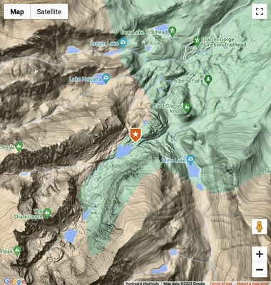
A 3.6 mile hike in from the RMNP Glacier Gorge TH brings you to a beautiful and private 1 campsite location from which to explore Andrews Creek Backcountry Area including Andrews Tarn, the Loch Vale Trail, and surrounding areas of interest. A wonderful way to spend a few days in the wilds of Rocky Mountain National Park.
Please view this document with everything you need to know about Rocky Mountain National Park
Suggested Backpacking Section (BPX) itinerary for 2-day trip to be used for CMC trips led by BPX leaders for BPX members:
Glacier Gorge TH: From Beaver Meadows Visitor Center follow Hwy 36 west to Bear Lake Road (approximately 1.3 miles). Turn left onto Bear Lake Road and follow for approximately 8 miles to the TH. Parking along road may result in your vehicle being towed. If TH parking is full, use another established parking lot or use the Shuttle Bus when it is available.
You'll hike in 3.6 miles to reach the Andrews Creek Campsite at 10,560'. It sits in a spruce and fir forest next to an avalanche debris field 0.2 miles above the junction of the Andrews Creek Trail and the Loch Vale Trail. From the campsite, you'll have opportunities to explore Andrews Tarn, a meltwater lake below Andrews Glacier and hike along the Continental Divide.
No privy is at the site so the park requires you to pack in and out two RESTOP wag bags for human waste. Water is available from Andrews Creek. Boil or treat all water before drinking. A maximum of two, up to four-person tents are allowed at the site. The maximum number of individuals is 7. The campsite, along with nearby Glacier Gorge campsite, is very popular so make early reservations, especially for weekends.
For information on obtain a RMNP wilderness camping permit, click on this link:
https://www.nps.gov/romo/planyourvisit/wilderness-camping.htm
For information on the Andrews Creek Area, click on this link:
https://www.nps.gov/romo/planyourvisit/andrews-creek.htm
- Suitable Activities: Backpacking
- Seasons: May, June, July, August, September, October
- Weather: View weather forecast
- Difficulty: Moderate
- Length: 7.2 mi
- Elevation Gain: 1,320 ft
- 10,560 ft
-
Land Manager:
National Park Service
Rocky Mountain National Park
- Parking Permit Required: National Park Entrance Fees
- Recommended Party Size: 6
- Maximum Party Size: 7
- Maximum Route/Place Capacity: 7
- https://www.nps.gov/romo/planyourvisit/upload/BCO-Map-20160205-clean-reduce==3D=3D3D=3D3D3D=3D3D3D3Dd.pdf
This is a list of titles that represent the variations of trips you can take at this route/place. This includes side trips, extensions and peak combinations. Not seeing a title that fits your trip? Log in and send us updates, images, or resources.
- BPX 2-Day: RMNP Andrews Creek Area
- BPX 3-Day: RMNP Andrews Creek Area
- BPX 4-Day: RMNP Andrews Creek Area
There are no resources for this route/place. Log in and send us updates, images, or resources.
