BPX 6-Day: CDT Wolf Creek Pass Lobo TH to Weminuche Pass Rio Grande Reservoir Thirty Mile TH
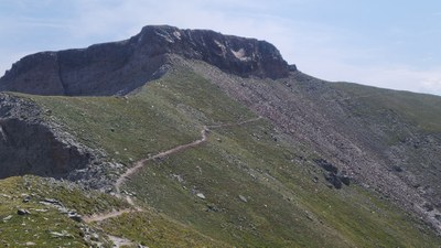
Enjoy the beautiful Weminuche Wilderness in the southern San Juan mountains along the Continental Divide Trail. Much of the trip is along the divide and above tree line with camping below tree line. This strenuous 54 miles trip is for experienced backpackers, but is the best of Colorado, passing by Sawtooth Mountain, camping at the unique hanging Cherokee Lake and going over The Knife Edge with descents to many high meadows and passes full of flowers.
Suggested Backpacking Section (BPX) itinerary for 6-day trip to be used for CMC trips led by BPX leaders for BPX members.
Itinerary is designed for shorter first and last day to allow time to drive to and from TH and shuttle cars between Lobo TH near Wolf Creek Pass and Thirty Mile TH at Rio Grande Reservoir - about 75 miles or reserve campsite at Thirty Mile Campground. Route direction is designed to minimize high elevation late in day. Do not attempt the Knife Edge before snow on the north side of ridge has melted. The route could be hiked in either direction - with Nobo having less elevation gain and easier first day, while Sobo has higher elevation earlier in the day for lightning avoidance.
Day 1: Wolf Creek Pass Lobo TH to Archuleta Lake. 8.9 miles and 1,754 feet elevation gain.
Day 2: Archuleta Lake to Piedra Pass. 11.3 miles and 2,692 feet elevation gain.
Day 3: Piedra Pass to Cherokee Lake. 13.4 miles and 3,181 feet elevation gain.
Day 4: Cherokee Lake to basin with lakes. 10.8 miles and 2,744 feet elevation gain.
Day 5: Basin with lakes to Weminuche Pass. 9.6 miles and 1,596 feet elevation gain.
Day 6: Weminuche Pass to Rio Grande Reservoir Thirty Mile TH. 6.5 miles and 350 feet elevation gain.
An alternate shorter distance or five day trip could be done by descending from Squaw Pass to Rio Grande Reservoir instead of Weminuche Pass.
- Suitable Activities: Backpacking
- Seasons: August, September
- Weather: View weather forecast
- Difficulty: Difficult
- Length: 51.6 mi
- Elevation Gain: 10,600 ft
- 12,868 ft
-
Land Manager:
U.S. Forest Service
Weminuche Wilderness Area, Divide Ranger District (RGNF)
- Parking Permit Required: USFS Permits & Passes
- Recommended Party Size: 6
- Maximum Party Size: 12
- Maximum Route/Place Capacity: 12
- Trails Illustrated 140
There are no resources for this route/place. Log in and send us updates, images, or resources.
