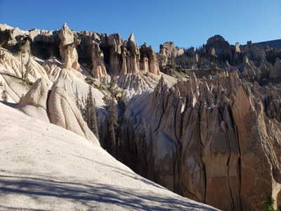
BPX 4-Day: Wheeler Geologic Area via Halfmoon Pass from South Fork Saguache TH
A truly unique and varied hike through scenic open country, alpine basins, over a high pass and down to the fantastic Wheeler Geologic Area with return via a large scenic mesa above tree line and down into a deep canyon. This 24.9 mile long, with 4,200 vertical feet, difficult trip, accesses the geological area from the north by going over Halfmoon pass.
Wheeler Geologic Area is part of the La Garita Wilderness in the Rio Grande National Forest in the San Juan Mountains. At one time, it was considered for being a National Park, but was determined to be too remote to get to, so it was 'preserved' as just a National Monument from 1908 to 1950 and since then has returned to the NFS. Within this area you’ll find many trails, some nearby 13,’ers, scenic and expansive views, and of course, the Wheeler Geologic Area.
Suggested Backpacking Section (BPX) itinerary for 4-day trip to be used for CMC trips led by BPX leaders for BPX members.
Day 1. Drive to South Fork Saguache TH - approximately five hours from Denver . Hike on the South Fork Saguache Trail (#781). Pass the Whale Creek Trail and continue on the South Fork Saguache Trail to the Unknown Creek Trail (#886). Hike on the Unknown Creek Trail to the Half-moon Pass Trail (#912). Hike on the Half Moon Pass Trail to the Half-moon Creek Trail (#914) and turn right on that trail. Camp along this trail next to Twin Peaks Creek. This loop gives you great views of Twin Peak above. (6 miles/1400’).
Day 2. An early morning out and back day hike is possible to Machin Lake west on the Machin Basin Trail (#784). Otherwise turn left (east) on the Machin Basin Trail towards Half-moon Pass. The Machin Basin Trail intersects with the Half-moon Pass Trail (#912) just below the pass. Summit the pass and descend on the Wheeler Trail (#790) to the Wheeler Geologic Area. Camping near the cabin shelter is not legal and there may not be water in the creek so decend to TH and camping may be required.. Explore the Wheeler Geologic area. (5.1 miles/ 1000’).
Day 3. Leave the WGA very early to get over Palmer Mesa before afternoon storms. Climb back up the Wheeler Trail towards Half-moon Pass. Just below the pass turn right (east) on the La Garita Stock Driveway (#787) Ascend to and cross Palmer Mesa. After 6 miles, turn south on the Whale Creek Trail (#780) and descend into the Whale Creek Canyon. It is possible to camp near where the trail first arrives at Whale Creek (7 miles to camp /1800’).
Day 4. Hike down Whale Creek Trail to the trailhead. (4.1 miles/0’).
General requirements and notes: Road to trailhead is gravel and in good condition with just a few rocky sections which are not bad and a passenger car could access. Trailhead has plenty of parking. The hiking route may be difficult to follow at times especially on Palmer Mesa where there is no trail, just widely spaced markers. GPS is critical. It is also critical to leave WGA early to get over the mesa before storms. There is an amazing, detailed and thorough website for this trip with maps and GPS data.
Notes:
Notes from 2020: Very good loop. NO CAMPING IN WHEELER GEOLOGICAL AREA OR WATER LATE IN DRY SEASON (mid-August 2020). Need to descend to Wheeler TH for water and camping but going in on one side of the Wheeler loop and out on the opposite worked well to see everything. Descent from Palmer Mesa into Whale Creek drainage is very steep on trail with loose rocks on hard pack and requires slow concentrated down climb which might be too much for some. Trail down Whale Creek drainage is not maintained and difficult to follow in some sections but carefully following GPS routes worked fine - you must hit the switchback area on target to get into the lower canyon.
- Suitable Activities: Backpacking
- Seasons: July, August, September
- Weather: View weather forecast
- Difficulty: Moderate
- Length: 24.9 mi
- Elevation Gain: 4,200 ft
- 12,400 ft
-
Land Manager:
U.S. Forest Service
La Garita Wilderness Area, Saguache Ranger District (RGNF)
- Parking Permit Required: USFS Permits & Passes
- Recommended Party Size: 6
- Maximum Party Size: 12
- Maximum Route/Place Capacity: 12
- Trails Illustrated 139
There are no resources for this route/place. Log in and send us updates, images, or resources.
