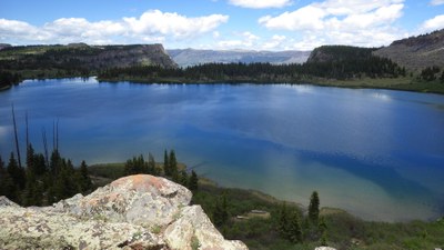
BPX 4-Day: Skinny Fish Lake from Skinny Fish TH then Wall Lake loop from Wall Lake TH
Hike into the west side of the Flat Tops Wilderness on this 'two-for' to beautiful Skinny Fish & Wall Lake and the famous Chinese Wall. Fish or explore the area. Total mileage for both trips is 21 with 3,800 vertical feet.
Suggested Backpacking Section (BPX) itinerary for 4-day trip to be used for CMC trips led by BPX leaders for BPX members.
Day 1 -- Drive to Skinny Fish Trailhead, near Trappers Lake, east of Meeker. Upon departing the Trailhead on Skinny Fish Trail (#1813), we will climb in the first mile some 600' of elevation. The trail will turn more to the east and contour its way for the next mile climbing only occasionally. The final climb of approximately 250' takes us north for the final 1/2 mile. Set up camp below the famous Chinese Wall and fish or explore the area until bedtime. Totals for the first day are 3 miles/1,000'.
Day 2. -- Break camp and return to the cars. The return trip is virtually all downhill, no elevation gain. At the trailhead we will load the cars and drive to Wall Lake trailhead, also near Trappers Lake, just a few minutes away to begin the Wall Lake Loop.
Route Day 1 and First 1/2 of Day 2
From the Wall Lake trailhead, we will take Wall Lake Trail (#1818) to the south and immediately enter spruce and lodgepole remains of the 2002 Big Fish Fire. The burned area continues for about 2 miles above Anderson Lake. This trail is one of the quickest but steepest routes up to the plateau. Once on the plateau, we pass the Oyster Lake Trail junction, but still have a couple of miles to the lake. Upon reaching the lake the trail stays to the west side of the lake and begins climbing "the wall." We'll look for a campsite and leave that climb for tomorrow. Mileage and elevation for this part of the day is 5 miles and 1500'. (Combined totals for the day, including our return from Skinny Fish Lake are 8 miles/1500'.)
Day 3 -- Break camp and begin climbing the wall south and east toward to a saddle into the South Fork drainage. From the saddle and through the meadows below, Shingle Peak dominates the landscape to the south. The trail continues across the alpine tundra for 2 miles ending at the Trappers Lake Trail. Turning northeast on Trappers Lake Trail (#1816) we will trek across the parks of the Flat Tops Wilderness plateau before turning north west to dip into Frazer Canyon. The rest of the day will be downhill. Taking a left fork onto Carhart Trail above Trappers Lake, we will end our trek back at the Wall Lake Trailhead, then seek the nearby Shepherd's Creek Campground to overnight. Travel for the day will be 10 miles/1300'
Day 4 -- break camp and drive home.
Route Second 1/2 Day 2 to Day 4
Alternate Trips: This trip could be broken up into 2 day or 3 day itineraries:
Two day - Skinny Fish & McGinnis only
Three day - Day 1 - Skinny Fish & McGinnis, Day 2 - Wall Lake, Day 3 - 10 miles out & drive home
Driving Directions: From Meeker, CO take Colorado Highway 13 east for 1 mile, then turn right (east) on Rio Blanco County Road 8 and follow this for 39 miles. Turn south on Trappers Lake Road #205, and travel 8 miles to the Skinny Fish Trailhead parking area.
- Suitable Activities: Backpacking
- Seasons: July, August, September
- Weather: View weather forecast
- Difficulty: Moderate
- Length: 21.0 mi
- Elevation Gain: 3,800 ft
- 11,289 ft
-
Land Manager:
U.S. Forest Service
Flat Tops Wilderness Area, Blanco Ranger District (WRNF)
- Parking Permit Required: USFS Permits & Passes
- Recommended Party Size: 6
- Maximum Party Size: 12
- Maximum Route/Place Capacity: 12
- Trails Illustrated 122
There are no resources for this route/place. Log in and send us updates, images, or resources.
