BPX 4-Day: Colorado National Monument Saddlehorn Campground
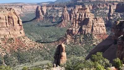
Colorado National Monument (the Monument) has been described as a "mini Grand Canyon". At 5800' Saddlehorn Campground is above the Grand Valley in a semi-arid pinon-juniper forest. Sandstone rock formations abound with scenic views of Book Cliffs. Balanced rocks, domes, canyons provide wonderous viewing.
Colorado National Monument requires an entry fee per vehicle unless the the driver or a passenger has a Golden Passport Pass
Saddlehorn Campground is about 12 miles west of Grand Junction inside Colorado National Monument. Taking the scenic Rim Rock Drive prior to checking in at the Visitor Center or setting up camp is highly recommended.
Saddlehorn has three paved loops with Loop A open year-round; Loop B sites have Grand Valley views; Loop C is first-come, first served year round with both individual and group sites.
Nearest town: Grand Junction, Fruita
Reservations: 6 months in advance www.recreation.gov 877 444 6777; Visitor Center
970 858 36`17
Group site info 970 858 3617 X 300; 3 tents per site permitted, recommend 2 per site,
Amenities: picnic tables, fire grates - charcoal only, potable water spigots, flush toilets, NO SHOWERS, no wood fires allowed in campground
Nearest 24/7 ER: Saint Mary's Hospital (Intermountain Health Care) 2635 N. 7th St, Grand Junction 970 298 2273
Mesa County Sheriff: 970 244 3500 Address - 215 Rice Street, Grand Junction
Driving: From Golden 250 miles/4.5 hours Directions - From Golden I-70 W to Exit 19, Fruita, take CO 340E to Rimrock Drive to Visitor Center @ 11 Rimrock Drive, Fruita
Fees: Campsite fees $22 x 3 sites x 3 nites/6 = $33 Baseline carpool fees: 500 miles x $.30/3 = $50. Leaders must pay for campsite fees in advance; reimbursement due date by participants is set by leader.
Baseline carpool fees are round trip only; additional mileage to trailheads can be added at end of trip. Some trailheads may require a 4WD or high clearance vehicle. Some trailheads may be closed due to weather conditions. Check at the Visitor Center.
Suggested Backpacking Section (BPX) itinerary for 4-day trip to be used for CMC trips led by BPX leaders for BPX members.
Note: CNM Trail treads will be rocky and uneven; there will be some scrambling, steep sections and brush; little to no water along most trails. Select an appropriate season for your group as temperatures in the Monument can reach into the high 80's - low 90's in June, July, August.
Day 1 - Drive to Visitor Center, explore, take Rimrock Drive through the Monument, make camp for 3 nights OR arrive in sufficient time to complete a short hike to Devil's Kitchen, 1.9 miles, Out and Back, 400'. Be certain to see photo in VC for specific rock formation named Devil's Kitchen.
Day 2 - Hike, leisure in camp, visit Dinosaur Museum, wildlife observation
Suggested trail sources - COTREX or All Trails; McGinnis Canyon National Conservation Area
Monument Canyon Out and Back, 7 miles, 850' from Rim Rock Drive or hike as a shuttle from Rim Rock Drive to a second trailhead at eastern edge of park of Hwy 340, same mileage and elevation gain. This hike has the most named rock formations with Independence Mountain being the tallest monolith at 450'.
Day 3 - Hike, leisure in camp
Suggested trails sources - see above Day 2
Liberty Cap to Ottos Tub, Out and Back, 8.8 miles, 685' gain
Day 4 - Break cap and return to meeting location
- Suitable Activities: Camping
- Seasons: March, April, May, June, July, August, September, October, November
- Weather: View weather forecast
- Difficulty: varies
- Length: 18.0 mi
- Elevation Gain: 1,900 ft
- 5,800 ft
-
Land Manager:
National Park Service
Colorado National Monument
- Parking Permit Required: National Park Entrance Fees
- Recommended Party Size: 6
- Maximum Party Size: 12
- Maximum Route/Place Capacity: 12
- Trails Illustrated 208
This is a list of titles that represent the variations of trips you can take at this route/place. This includes side trips, extensions and peak combinations. Not seeing a title that fits your trip? Log in and send us updates, images, or resources.
- Camping
There are no resources for this route/place. Log in and send us updates, images, or resources.
